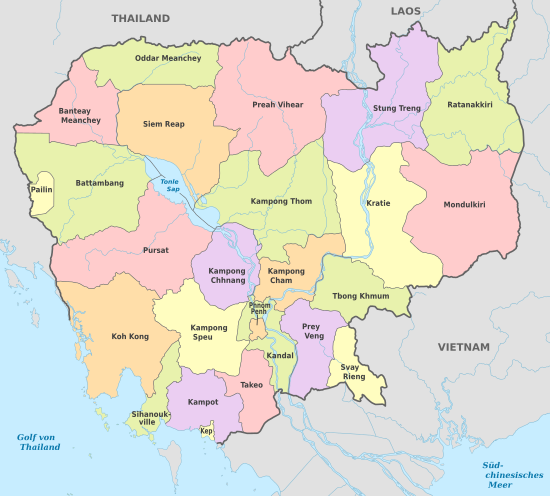
Geography of Cambodia
The south and south-west of the country constitute a 443 km (275 mi) long coast at the Gulf of Thailand, characterized by sizable mangrove marshes, peninsulas, sandy beaches and headlands and bays.
After extensive rapids, turbulent sections and cataracts in Laos, the river enters the country at Stung Treng province, is predominantly calm and navigable during the entire year as it widens considerably in the lowlands.
[7][8] Two third of the country's population live in the lowlands, where the rich sediment deposited during the Mekong's annual flooding makes the agricultural lands highly fertile.
As deforestation and over-exploitation affected Cambodia only in recent decades, forests, low mountain ranges and local eco-regions still retain much of their natural potential and although still home to the largest areas of contiguous and intact forests in mainland Southeast Asia, multiple serious environmental issues persist and accumulate, which are closely related to rapid population growth, uncontrolled globalization and inconsequential administration.
[9][10][11][12][13] The majority of the country lies within the Tropical savanna climate zone, as the coastal areas in the South and West receive noticeably more and steady rain before and during the wet season.
Countrywide there are two seasons of relatively equal length, defined by varying precipitation as temperatures and humidity are generally high and steady throughout the entire year.
These include the South China, Indochina, Sibumasu, and West Burma blocks, which amalgamated to form the Southeast Asian continent during the Paleozoic and Mesozoic periods.
[21][22] Bowl- or saucer-shaped,[23][24] Cambodia covers 181,035 km2 (69,898 sq mi) in the south-western part of the Indochinese peninsula as its landmass and marine territory is situated entirely within the tropics.
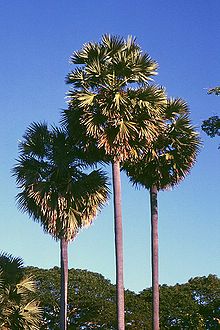
[25][26] Domestic plants, such as sugar palms, Coconut trees and banana groves almost exclusively skirt extensive rice paddies, as natural vegetation is confined to elevated lands and near waterways.
Cambodia's low mountain ranges - representing the walls of the bowl - remain as the result of only rather recent substantial infrastructural development and economic exploitation - in particular in remote areas - formidably forested.
[29][30] A heavily indented coastline at the Gulf of Thailand of 443 km (275 mi) length and 60 offshore islands, that dot the territorial waters and locally merge with tidal mangrove marshes - the environmental basis for a remarkable range of marine and coastal eco-regions.
Low fertility and toxic amounts of aluminium pose limitations to its agricultural use, crops that can be successfully cultivated include rubber tree, oil palm, coffee and sugar cane.
"[33] The vast alluvial and lacustrine interconnected Cambodian flood-plain is a geologically relatively recent depression where the sediments of the Mekong and its tributaries accumulate as waters are subject to frequent course changes.
[38][39] The Mekong branches off into several arms near Phnom Penh and reaches Vietnamese territory south of Koh Thom and Loek Daek districts of Kandal Province.
Extending 110 km (68 mi) north from the Gulf of Thailand, they reach a high point in the Bok Koŭ ridge at Mount Bokor 1,081 m (3,547 ft) near the sea.
[46][47][48][49] To the south-west of the Southern mountain ranges extends a narrow coastal plain that contains the Kampong Saom Bay area and the Sihanoukville peninsula, facing the Gulf of Thailand.
The Dangrek Mountains A forested range of hills averaging 450 to 600 m (1,480 to 1,970 ft), dividing Thailand from Cambodia, mainly formed of massive sandstone with slate and silt.
Illegal logging are issues on both, the Thai as well as on the Cambodian side, leaving large hill stretches denuded, vulnerable tree species such as Dalbergia cochinchinensis have been affected.
[55] Tall grasses and deciduous forests cover the ground east of the Mekong River in Mondulkiri, where the transitional plains merge with the eastern highlands at altitudes from 200 to 1,000 m (660 to 3,280 ft).
The landscape has suffered from rubber farming, logging and particularly mining, although sizable areas of pristine jungle survive, which are home to rare and endemic wildlife.
[62][63] Cambodia's climate, like that of much of the rest of mainland Southeast Asia is dominated by monsoons, which are known as tropical wet and dry because of the distinctly marked seasonal differences.
In spring, the flow of the Mekong River, fed by monsoon rains, increases to a point where its outlets through the delta can't handle the enormous volume of water.
The annual flooding, combined with poor drainage immediately around the lake, transforms the surrounding area into marshlands, unusable for agricultural purposes during the dry season.
The complex geological, topographic and climatic ( rainfall and temperature ) facets that characterize the region make forest structure and composition unique and very variable.
[100] The area’s extensive wetland habitats are the product of the annual Mekong maximum, the simultaneous wet season and the drainage paths of a number of minor rivers.
In addition to mangroves, sea-grass beds extend throughout the coastal areas, especially in Kampot Province, the Sihanoukville Bay Delta and the Kep municipal waters.
Subsequent oil and gas discoveries in the Gulf of Thailand and in the South China Sea, however, could spark renewed interest in Cambodia's offshore area, especially because the country is on the same continental shelf as its Southeast Asian oil-producing neighbors.
"[130]Issues A nascent environmental movement has been noticed by NGO's - and it is gaining strength, as the example of local resistance against the building of a Chinese hydro-electric dam in the Areng Valley shows.
The EPI was established in 2001 by the World Economic Forum as a global gauge to measure how well individual countries perform in implementing the United Nations' Sustainable Development Goals.
[137][138][139] In November 2017, the U.S. cut funds to help clear unexploded ordnance including land mines and chemical weapons in Cambodia which it had dropped during the Vietnam War.