Geography of Egypt
Egypt borders Libya to the west, Palestine and Israel to the east and Sudan to the south (with a current dispute over the halaib triangle).
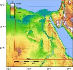
Most of the country lies within the wide band of desert that stretches eastwards from Africa's Atlantic Coast across the continent and into southwest Asia.
[3] The Nile Valley and Delta, the most extensive oasis on earth, was created by the world's longest river and its seemingly inexhaustible sources.
But, in late summer, when torrential rains fall on the Ethiopian Highlands, the Atbarah provides 22% of the Nile's flow.
The great flood of the main Nile usually occurred in Egypt during August, September, and October, but it sometimes began as early as June at Aswan and often did not completely wane until January.
Lake Nasser's waters fill the area through Lower Nubia (Upper Egypt and northern Sudan) within the narrow canyon between the cliffs of sandstone and granite created by the flow of the river over many centuries.
In the north, near the coast, the Nile delta embraces a series of salt marshes and lakes, the most notable among which are Idku, Al Burullus, and Manzilah.
This immense desert to the west of the Nile spans the area from the Mediterranean Sea southwards to the Sudanese border.
The Great Sand Sea lies within the desert's plain and extends from the Siwa Oasis to Jilf al Kabir.
Escarpments (ridges) and deep depressions (basins) exist in several parts of the Western Desert, and no rivers or streams drain into or out of the area.
There are seven important depressions in the Western Desert, and all are considered oases except the largest, Qattara, the water of which is salty.
The Qattara Depression, which includes the country's lowest point, encompasses 19,605 square kilometers (7,570 sq mi), which is similar to the size of Lake Ontario.
Limited agricultural production, the presence of some natural resources, and permanent settlements are found in the other six depressions, all of which have fresh water provided by the Nile or by local groundwater.
The Siwah Oasis, close to the Libyan border and west of Qattara, is isolated from the rest of Egypt but has sustained life since ancient times.
The other major oases form a topographic chain of basins extending from the Faiyum Oasis (sometimes called the Fayyum Depression) which lies 60 kilometers (37 mi) southwest of Cairo, south to the Bahariya, Farafirah, and Dakhilah oases before reaching the country's largest oasis, Kharijah.
A brackish lake, Birket Qarun, at the northern reaches of Al Fayyum Oasis, drained into the Nile in ancient times.
For centuries sweet water artesian wells in the Fayyum Oasis have permitted extensive cultivation in an irrigated area that extends over 1,800 square kilometers (695 sq mi).
The elevation rises abruptly from the Nile, and a downward-sloping plateau of sand gives way within 100 km to arid, defoliated, rocky hills running north and south between the Sudan border and the Delta.
The southern side of the peninsula has a sharp escarpment that subsides after a narrow coastal shelf that slopes into the Red Sea and the Gulf of Aqaba.
The northern third of Sinai is a flat, sandy coastal plain, which extends from the Suez Canal into the Gaza Strip and Israel.
Many of these creatures will only be apparent from their tracks and trails or from a fleeting glimpse of a diminutive gerbil, or zig-zigging hare, in the car headlights at night.
Agriculture is a key component of the economy in rural areas, though some people are employed in the tourist industry or other non-farm occupations.