Geography of Iran
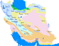
Topographically, it is predominantly located on the Iranian/Persian plateau, Its mountains have impacted both the political and the economic history of the country for several centuries.
Until the 20th century, when major highways and railroads were constructed through the mountains to connect the population centers, these basins tended to be relatively isolated from one another.
In the higher elevations of the mountains rimming the basins, tribally organized groups practiced transhumance, moving with their herds of sheep and goats between traditionally established summer and winter pastures.
There are no major river systems in the country, and historically transportation was by means of caravans that followed routes traversing gaps and passes in the mountains.
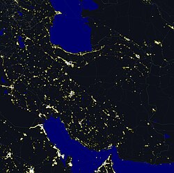
With an area of 1,648,195 square kilometres (636,372 sq mi), Iran ranks seventeenth in size among the countries of the world.
Iran's diagonal distance from Azerbaijan in the northwest to Sistan and Baluchestan province in the southeast is approximately 2,333 kilometres (1,450 mi).
It extends for about 120 kilometres (75 mi) inland, barely rising a few meters above sea level, then meets abruptly with the first foothills of the Zagros.
In the south, winters are mild and summers are very hot, with average daily maximum temperature exceeding 38 °C (100.4 °F) in the month of July.
The major exceptions are the higher mountain valleys of the Zagros and the Caspian coastal plain, where precipitation averages at least 600 millimetres (24 in) and is in the form of snow at high altitudes.
The most extensive growths are found on the mountain slopes rising from the Caspian Sea, with stands of oak, ash, elm, cypress, and other valuable trees.
On the plateau proper, areas of scrub oak appear on the best-watered mountain slopes, and villagers cultivate orchards and grow the plane tree, poplar, willow, walnut, beech, maple, and mulberry.
Domestic animals include, sheep, goats, cattle, horses, water buffalo, donkeys, and camels.
The Asiatic cheetah is a critically endangered species which is extinct elsewhere and now can only be found in central to northeastern parts of Iran.
Domestic animals include sheep, goats, cattle, horses, water buffalo, donkeys, and camels.
[66] Natural hazards: periodic droughts, floods; dust storms, sandstorms; earthquakes along western border and in the northeast Environment – current issues: air pollution, especially in urban areas, from vehicle emissions, refinery operations, and industrial effluents; deforestation; desertification; oil pollution in the Persian Gulf; wetland losses from drought; soil degradation (salination); inadequate supplies of potable water in some areas; water pollution from raw sewage and industrial waste; urbanization.
The country protests Afghanistan's limiting flow of dammed tributaries to the Helmand River in periods of drought.
The lack of a maritime boundary in the Persian Gulf with Iraq also prompts jurisdictional disputes beyond the mouth of the Arvand Rud.