Geography of Nepal
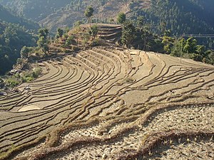
The Hilly region, encompassing 68% of the country's area, consists of mountainous terrain without snow and is inhabited by various indigenous ethnic groups.
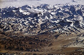
The Himal region, covering 15% of Nepal's area, contains snow and is home to several high mountain ranges, including Mount Everest, the world's highest peak.
The diverse elevation results in various biomes, including tropical savannas, subtropical and temperate forests, montane grasslands, and shrublands.
A few tens kilometers further north the high Himalaya abruptly rise along the Main Central Thrust fault zone above the snow line at 5,000 to 5,500 metres (16,400 to 18,000 ft).
Paharis mainly populate river and stream bottoms that enable rice cultivation and are warm enough for winter/spring crops of wheat and potato.
Other indigenous Janajati ethnic groups -— natively speaking highly localized Tibeto-Burman languages and dialects -— populate hillsides up to about 2,500 metres (8,000 ft).
Grain production has not kept pace with population growth at elevations above 1,000 metres (3,300 ft) where colder temperatures inhibit double cropping.
Industrialization based on agricultural products such as jute began in the 1930s and infrastructure such as roadways, railways and electricity were extended across the border before it reached Nepal's Pahad region.
This range is composed of poorly consolidated, coarse sediments that do not retain water or support soil development so there is virtually no agricultural potential and sparse population.
It experiences frost up to 53 days per year, however, this varies greatly with elevation, proximity to high mountains and terrain either draining or ponding cold air drainage.
Crops include cold-tolerant rice, maize, wheat, barley, potato, apple, walnut, peach, various cole, amaranthus and buckwheat.
It has permanent settlements in the Himalaya, but further south it is only seasonally occupied as pasture for sheep, goats, yak and hybrids in warmer months.
Annual precipitation reaches 5,500 mm (18 ft) on windward slopes in the Annapurna Himalaya beyond a relatively low stretch of the Lower Himalayan Range.
The year is divided into a wet season from June to September—as summer warmth over Inner Asia creates a low-pressure zone that draws in moist air from the Indian Ocean—and a dry season from October to June as cold temperatures in the vast interior create a high-pressure zone causing dry air to flow outward.
April and May are months of intense water stress when cumulative effects of the long dry season are exacerbated by temperatures rising over 40 °C (104 °F) in the tropical climate belt.
Seasonal drought further intensifies in the Siwaliks hills consisting of poorly consolidated, coarse, permeable sediments that do not retain water, so hillsides are often covered with drought-tolerant scrub forest.
In fact, much of Nepal's native vegetation adapted to withstand drought, but less so at higher elevations where cooler temperatures mean less water stress.
Sustained rain on average arrives in mid-June as rising temperatures over Inner Asia creates a low-pressure zone that draws in moist air from the Indian Ocean, but this can vary up to a month.
After the post-monsoon comes the winter monsoon, a strong northeasterly flow marked by occasional, short rainfalls in the lowlands and plains and snowfalls in the high-altitude areas.
In this season the Himalayas function as a barrier to cold air masses from Inner Asia, so southern Nepal and northern India have warmer winters than would otherwise be the case.
The largest systems -— from east to west the Koshi, Gandaki/Narayani, Karnali/Goghra and Mahakali—originate in multiple tributaries rising in or beyond the high Himalaya that maintain substantial flows from snowmelt through the hot, drought-stricken spring before the summer monsoon.
The Kali Gandaki rises on the edge of the Tibetan Plateau and flows through the semi-independent Kingdom of Mustang, then between the 8,000 meter Dhaulagiri and Annapurna ranges in the world's deepest valley.
The area around these features is the hydrographic nexus of South Asia since it holds the sources of the Indus and its major tributary the Sutlej, the Karnali—a Ganges tributary—and the Yarlung Tsangpo/Brahmaputra.
Koshi River in the first category caused a major flood in August 2008 in Bihar state, India after breaking through a poorly maintained embankment just inside Nepal.
[13] Since uplift and erosion are more or less in equilibrium in the Himalaya, at least where the climate is humid,[14] rapid uplift must be balanced out by annual increments of millions tonnes of sediments washing down from the mountains; then on the plains settling out of suspension on vast alluvial fans over which rivers meander and change course at least every few decades, causing some experts to question whether manmade embankments can contain the problem of flooding.
[17] Depletion of aquifers without building upstream dams as a sustainable alternative water source could precipitate a Malthusian catastrophe in India's food insecure states Uttar Pradesh[citation needed] and Bihar,[18] with over 300 million combined population.
[20] As Nepal builds barrages to divert more water for irrigation during the dry season preceding the summer monsoon, there is less for downstream users in Bangladesh and India's Bihar and Uttar Pradesh states.
The best solution could be building large upstream reservoirs, to capture and store surplus flows during the summer monsoon as well as providing flood control benefits to Bangladesh and India.
[23] Fourth, there are complicated questions of cross-border equity in how India and Nepal would share costs and benefits that have proven difficult to resolve in the context of frequent acrimony between the two countries.
Despite the availability of liquefied petroleum gas in towns and cities, firewood is sold more at energy-competitive prices because cutting and selling it is a fallback when better employment opportunities aren't forthcoming.