Geology of the Bryce Canyon area
After Laramide mountain building came to an end, about 15 mya, a large part of western North America began to be stretched into the nearby Basin and Range topography.
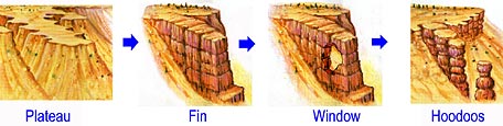
The uplift caused the formation of vertical joints which were later preferentially eroded to form the free-standing pinnacles called hoodoos, badlands, and monoliths we see today.
[4] In the Bryce Canyon area, this formation can be seen in the Paria Valley where it is found as a lithified blanket sand that probably accumulated on beaches, in lagoons, and vast coal-producing swamps as the Cretaceous Seaway transgressed (advanced inland) over the region and later retreated.
[6] The resulting dark gray to black Tropic Shale records the maximum transgression of the seaway into Utah and is 1,000 feet (300 m) thick in the Paria Amphitheater.
[4] The Cretaceous Seaway was already retreating east and to the south by the time the locally 1,700 feet (500 m) thick Straight Cliffs Formation was deposited.
The cliff-forming sandstone of the Tibbet Canyon Member was conformably deposited on top of the Tropic Shale in shallow marine and later near shore environments.
Shale and sandstone from the Smoky Hollow Member were deposited on top of its basal layer of coal-rich mudstone in coastal swamps and lagoons on the shore of the seaway.
[7] This formation erodes into almost unclimbable cliffs and escarpments of whitish to yellow-gray sandstones with comparatively thin interbedded layers of shale and mudstone.
[7] Two formations, the Canaan Peak and the Pine Hollow, sit on top of the Kaiparowits elsewhere in the region but are absent in the Bryce Canyon area.
[7] Uplift caused by a mountain-building episode called the Laramide orogeny lasted from the late Cretaceous around 70 mya to the early Paleocene.
Periodic but extensive floods inundated large areas perhaps once every 1,000 years; spreading mud, cobbles and fine silt over the plains.
[7] Channelized conglomerates of this member can be easily seen in Red Canyon along State Route 12 while its silt and mudstones compose most of the park's fragile and colorful spires called hoodoos.
Geologist Clarence Dutton called the iron oxide-rich lower member of the Claron the Pink Cliffs series due to its colorful appearance.
[8] A large system of shallow but expansive lakes and associated deltas covered several thousand square miles of what is now northwest Colorado and southwest Utah and Wyoming.
As they did so, they left beds of differing thickness and composition stacked atop one another;[8] The limey oozes and mud were later lithified into the limestone and interbedded siltstone of the up-to-300 foot (90 m)-thick White Member of the Claron.
A gap in the geologic record following deposition of the Claron Formation was interrupted 34 to 31 mya by eruptions from the nearby Marysvale volcanic field, which is located northwest of the park.
[12] The Marysvale volcanic field collapsed under its own weight around 20 mya; likely due to weaknesses in the evaporites of the Carmel Formation some 5,000 feet (2,000 m) below.
[14] The Boat Mesa is made mostly of conglomerates with minor amounts of sandstone and some limestone from lakes, representing stream and overbank flood deposits.
[7][14] Around 15 mya in Miocene time, tensional forces in Nevada to the west were so great that the crust was spread thin, creating the Basin and Range Province.
[5] These same forces segmented what is now the western part of the Colorado Plateau into nine different smaller plateaus, including the Paunsaugunt that the park sits astride.
[16] The Hurricane Fault marks the west edge of the Markagunt Plateau and is the topographic boundary between the Basin and Range and the Colorado Plateaus provinces.
Formation of approximately the current depth of the Colorado River's Grand Canyon by 1.2 mya further caused its tributaries to cut down even deeper.
[19] As the canyon continues to erode to the west it will eventually capture (in perhaps 3 million years) the watershed of the East Fork of the Sevier River.
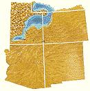
A diversion canal called the Tropic Ditch has been taking some or all of water from the East Fork of the Sevier River through this section of the park for over 100 years.