Geology of the Capitol Reef area
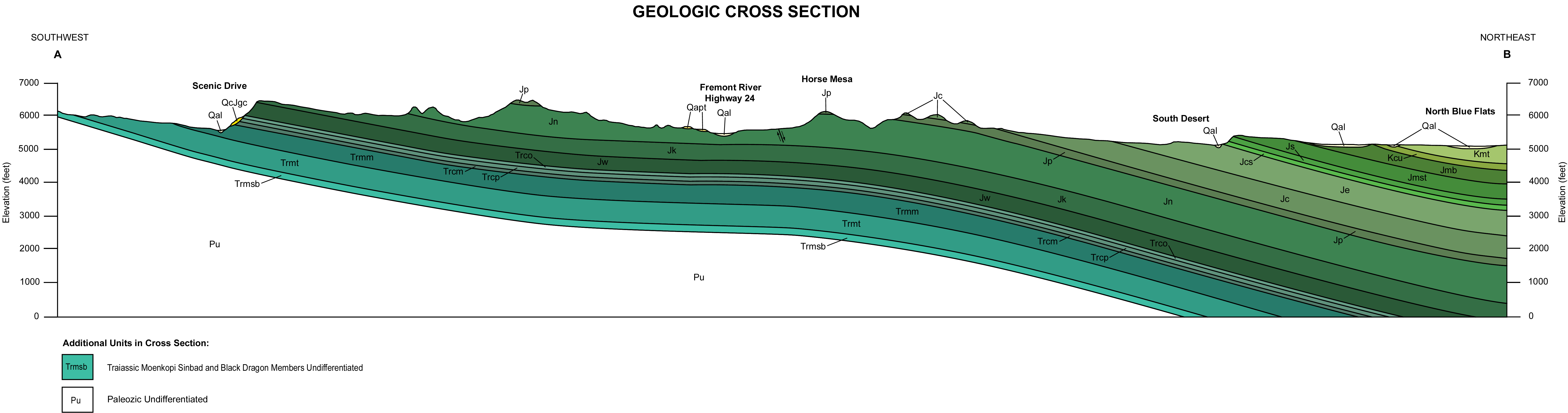
Nearly 10,000 feet (3,000 m) of sedimentary strata are found in the Capitol Reef area, representing nearly 200 million years of geologic history of the south-central part of the U.S. state of Utah.
)[1] Rock layers in the area reveal ancient climates as varied as rivers and swamps (Chinle Formation), Sahara-like deserts (Navajo Sandstone), and shallow ocean (Mancos Shale).
[5] The White Rim and Cedar Mesa are composed of fossilized cross-bedded sand dunes that were likely deposited in an arid coastal environment that periodically flooded with sea water.
[8] Retreat of the Kaibab Sea by the Mid Permian exposed its seabed to erosion, resulting in 100 foot (30 m) deep channels and the creation of a gap in the geologic record called an unconformity.
Uplift and subsequent partial erosion of the Moenkopi then created an approximately 6 million year long unconformity that lasted the entire Mid Triassic.
[6] Later in the early Triassic, fossil-rich to muddy limey ooze with small amounts of silt and sand were laid down as a short-lived arm of the ocean covered the region.
Logs, sand, mud and wind-transported volcanic ash from distant eruptions were mixed by streams as they migrated over a subsiding basin to form the Chinle.
Uranium salts accumulated in this formation in economically extractable quantities and petrified wood was formed (petrification was probably aided by the presence of volcanic ash).
[7] Chinle members represented in the Capitol Reef area are (from oldest to youngest):[10] Together they form the purple and orange rounded slopes and hills that are occasionally above white cliffs along the Waterpocket Fold's west face.
[10] Discontinuous beds of sediment were deposited in broad channels eroded into the Moenkopi, creating the locally 0 to 90 foot (0 to 27 m) thick white to yellowish gray cliff-forming Shinarump Member of the Chinle Formation.
Good outcrops of the Shinarump are found near the park's west entrance capping such features as the Egyptian Temple and Chimney Rock while all traces of this member are absent further east.
As this occurred, bentonite-rich clay (formed in part from volcanic ash erupted from nearby volcanoes) and clayey cross-bedded sand with some interbeds and lenses of lime ooze were laid down.
[10] This member easily stands out in the lower to middle slopes of the Waterpocket Fold's west face in such places as The Castle and along the cliff's just north of State Route 24 as it enters the park.
[10] The Owl Rock is made of purple and orange mudstones, fine-grained sandstones and siltstones with interbedded 1 to 10 foot (30 to 300 cm) thick green to mottled pink micritic and knobby limestone.
[10] Fossilized desiccation mudcracks that are up to 4 inches (10 cm) wide and 3 feet (1 m) deep are found at the very top of the Owl Rock (they were later filled with sand from the overlying Wingate Sandstone).
[11] They are, from oldest (lowest) to youngest (highest); Sand dunes migrated back and forth on the shore of the Sundance Sea, creating the 350 foot (107 m) thick cliff-forming Wingate Sandstone.
Slow-moving, southwestward flowing braided streams laid down thin-bedded layers of sand, silt, mud and cobbles in channels, across low flood plains and in lakes.
[11] A massive Sahara-like desert geologists call an erg then invaded the area, covering it with 800 to 1,100 feet (240 to 335 m) of accumulated white to tan-colored fossilized sand dunes.
In Mid Jurassic time gypsum, sand, and limey silt were deposited in what may have been a graben that was periodically covered by sea water and thus a place where repeated flooding was followed by evaporation.
[13] The resulting Carmel Formation is composed of 200 to 1,000 feet (60 to 300 m) of reddish-brown siltstone, mudstone and sandstone that alternates with whitish-gray gypsum and fossil-rich limestone in a banded pattern.
Fine-grained sand and silt mixed with sandy lime were laid down as sediments on top of the Entrada Sandstone, forming the locally 0 to 175 foot (53 m) thick erosion-resistant Curtis Formation.
Clay, mud, silt, cross-bedded sand, and pebbles were later deposited by meandering streams and in flood plains, forming the locally 100 to 500 foot (30 to 150 m) thick Salt Wash Member.
Salt Wash sandstone is moderately sorted and fine to medium grained while pebble conglomerate beds are made of chert with small amounts of silica-rich limestone.
The Salt Wash was locally mined in the 1950s to extract uranium ore.[15] The 200 to 350 foot (60 to 105 m) thick Brushy Basin Member is composed of claystone, mudstone, and siltstone with small amounts of conglomerate and sandstone.
The 73 foot (22 m) thick Buckhorn Conglomerate Member thins out north and east of the park and is nearly absent in it, making it difficult to distinguish the underlying Morrison from the somewhat more pastel-colored Cedar Mountain.
[16] Fossilized freshwater animals such as mollusks and ostracods along with dinosaurs, fish scales, pollen and a genus of fern called Tempskya have been found in this formation.
[17] The up to 150 foot (45 m) thick formation consists of fine-grained tan to brownish-gray colored quartz-rich sandstone that is interbedded with thin layers of carbon-rich shale, coal, and conglomerate.
Ferron Sandstone north of the area contains seams of coal in its upper part, prompting some petroleum geologists to study this member to model oil-bearing regions.
Subsequent erosion preferentially removed the softer sedimentary rock that initially entombed the dikes, sills, and volcanic plugs, often leaving them standing in relief.
Ten to fifteen million years ago the entire region was uplifted several thousand feet (well over a kilometer) by the creation of the Colorado Plateaus.


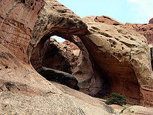


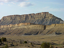


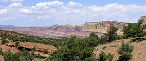
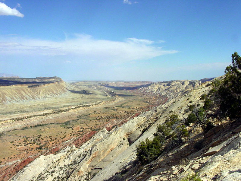
Photo of the fold looking south from the Strike Valley Overlook (USGS)