Geomatics
[1] Under another definition, it consists of products, services and tools involved in the collection, integration and management of geographic (geospatial) data.
[3][4] The term was proposed in French ("géomatique") at the end of the 1960s by scientist Bernard Dubuisson to reflect at the time recent changes in the jobs of surveyor and photogrammetrist.
[5] The term was first employed in a French Ministry of Public Works memorandum dated 1 June 1971 instituting a "standing committee of geomatics" in the government.
[citation needed] Geoinformatics and Geographic information science has been proposed as alternative comprehensive term; however, their popularity is, like geomatics, largely dependent on country.
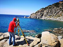
Geomatics engineers design, develop, and operate systems for collecting and analyzing spatial information about the land, the oceans, natural resources, and manmade features.