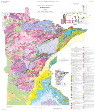
Geology of Minnesota
During this time, the state's Precambrian bedrock was formed by volcanism and the deposition of sedimentary rock and then modified by processes such as faulting, folding and erosion.
In the third and most recent period starting about 1.8 million years ago, glaciation eroded previous rock formations and deposited deep layers of glacial till over most of the state, and created the beds and valleys of modern lakes and rivers.
Precambrian bedrock has been mined for metallic minerals, including iron ore, on which the economy of Northeast Minnesota was built.
Minnesota contains some of the oldest rocks on Earth, granitic gneisses that formed some 3,600 mya (million years ago) — roughly 80% the age of the planet.
[6] While the crustal tectonic plates continued their slow drift over the surface of the planet, meeting and separating in the successive collision and sundering of continents, the North American craton remained stable.
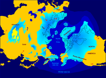
[8] Five hundred fifty million years ago, the state was repeatedly inundated with water of a shallow sea that grew and receded through several cycles.
Eventually, the ice sheet melted, and the Red River gave Lake Agassiz a northern outlet toward Hudson Bay.
In the absence of glacial scouring and drift, this region presents a widespread and highly dissected aspect absent from other parts of the state.
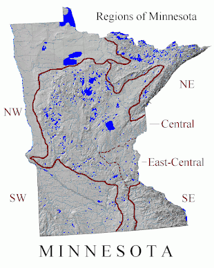
As glaciation and its residue has largely dictated regional surface geology and topography, Sansome's divisions are often coextensive with ecological provinces, sections, and subsections.
Excluded are parts of the beds of glacial lakes Agassiz and Upham, the latter now occupied by the upper valley of the Saint Louis River and its tributary the Cloquet.
There are surface exposures of rocks first formed in volcanic activity some 2,700 mya during construction of the Archaen-Superior province,[18] including Ely greenstone, metamorphosed and highly folded volcanics once thought to be the oldest exposed rock on earth;[19] Proterozoic formations created about 1,900 mya that gave the area most of its mineral riches; and more recent intrusive gabbro and extrusive basalts and rhyolites of the Duluth Complex and North Shore Volcanic Group, created by magma and lava which upwelled and hardened about 1,100 mya during the Midcontinent Rift.
Topsoils are thin and poor and their parent soils derived from the rock beneath or nearby rather than from glacial till, which is sparse.
In the remainder of the region, lakes provide recreation, forests are managed for pulpwood, and the underlying bedrock is mined for valuable ores deposited in Precambrian times.
The state's iron mines have produced over three and a half billion metric tons of ore.[23] While high-grade ores have now been exhausted, lower-grade taconite continues to supply a large proportion of the nation's needs.
[27] Bedrock in this region is mainly Archean, with small areas of Lower Paleozoic and Upper Mesozoic sedimentary rocks along the western border.
[28] By late Wisconsinan times this bedrock had been covered by clayey glacial drift scoured and transported south from sedimentary rocks in Manitoba.
[29] In the western part of the region in the Red River Valley, fine-grained glacial lake deposits and decayed organic materials up to 50 meters in depth form rich, well-textured, and moisture-retentive, yet well-drained soils (mollisols), which are ideal for agriculture.
The Coteau des Prairies divides the Minnesota and Missouri River valleys, and is a striking landform created by the bifurcation of different lobes of glacial advance.
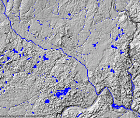
Once rich in wetlands known as prairie potholes,[36] 90%, or some three million acres (12,000 km²), have been drained for agriculture in the Minnesota River basin.
[12] Ojakangas and Matsch extend the region west past the moraine to a line running north from the Iowa border between Mankato and New Ulm to the latitude of the Twin Cities, then encompassing the latter metropolis with a broad arc east to the St. Croix River.
[39] Under Sansome's classification (followed here), Southeastern Minnesota is generally coterminous with the Paleozoic Plateau Section of the Eastern Broadleaf Forest Province.
It is an area of karst topography, with thin topsoils lying atop porous limestones, leading to formation of caverns and sinkholes.
The bedrock ranges in age from Archean granites to Upper Mesozoic Cretaceous sediments,[43] and underlying the eastern part of the region (and the southerly extension to Iowa) are the Late Precambrian Keweenawan volcanics of the Midcontinent Rift, overlaid by thousands of meters of sedimentary rocks.
[45] The region has the same types of glacial landforms as the remainder of Central Minnesota, but is distinguished by its bedrock valleys, both active and buried.
At St. Anthony Falls, the Mississippi dropped 50 feet (15 m) over a limestone ledge; these waterfalls were used to drive the flour mills that were the foundation for the city's 19th century growth.
[47] Along the eastern edge of the region are the Dalles of the St. Croix River, a deep gorge cut by runoff from Glacial Lake Duluth into ancient bedrock.
[48] Interstate Park here contains the southernmost surface exposure of the Precambrian lava flows of the Midcontinent Rift, providing a glimpse of Minnesota's volcanic past.