1964 Alaska earthquake
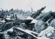
Anchorage sustained great destruction or damage to many inadequately earthquake-engineered houses, buildings, and infrastructure (paved streets, sidewalks, water and sewer mains, electrical systems, and other man-made equipment), particularly in the several landslide zones along Knik Arm.
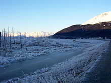
Southeast of Anchorage, areas around the head of Turnagain Arm near Girdwood and Portage dropped as much as 8 feet (2.4 m), requiring reconstruction and fill to raise the Seward Highway above the new high tide mark.
Post-quake tsunamis severely affected Whittier, Seward, Kodiak, and other Alaskan communities, as well as people and property in British Columbia, Washington, Oregon, and California.
Subsidence was observed for 285,000 km2 (110,000 sq mi) from north and west of the sound, in Chugach Mountains, most of Kenai Peninsula, and almost all the Kodiak Island group.
Tsunami waves were noted in over 20 countries, including Peru, New Zealand, Papua New Guinea, Japan, Mexico, and in the continent of Antarctica.
Land overlooking the Ship Creek valley near the Alaska Railroad yards also slid, destroying many acres of buildings and city blocks in downtown Anchorage.
[citation needed] The hamlets of Girdwood and Portage, located 30 and 40 mi (48 and 64 km) southeast of central Anchorage on the Turnagain Arm, were destroyed by subsidence and subsequent tidal action.
Valdez with 32 dead was not totally destroyed, but after three years, the town relocated to higher ground four miles (6.4 km) west of its original site.
[citation needed] The earthquake caused the ballistic missile detection radar of Clear Air Force Station to go offline for six minutes,[18] the only unscheduled interruption in its operational history.
Near Cordova, the Million Dollar Bridge crossing the Copper River also suffered damage, with Span #4 slipping off its pylon and collapsing.
Only the ground immediately along the highway and that on the north side of the road dropped, prompting geologists to speculate that Girdwood may rest upon an ancient cliff face covered by thousands of years of sediment and glacial deposits.
[citation needed] A 4.5 ft (1.4 m) wave reached Prince Rupert, British Columbia, just south of the Alaska Panhandle, about three hours after the earthquake.
The tsunami then reached Tofino, on the exposed west coast of Vancouver Island, and traveled up a fjord to hit Port Alberni twice, washing away 55 homes and damaging 375 others.
[28] Alaska had never experienced a major disaster in a highly populated area before, and had very limited resources for dealing with the effects of such an event.
The U.S. Army rapidly re-established communications with the lower 48 states, deployed troops to assist the citizens of Anchorage, and dispatched a convoy to Valdez.
[33] On the advice of military and civilian leaders, President Lyndon B. Johnson declared all of Alaska a major disaster area the day after the quake.
[35] Chance provided breaking news of the catastrophic events that continued to develop following the magnitude 9.2 earthquake, and she served as the voice of the public safety office, coordinating response efforts, connecting available resources to needs around the community, disseminating information about shelters and prepared food rations, passing messages of well-being between loved ones, and helping to reunite families.
[36] In the longer term, the U.S. Army Corps of Engineers led the effort to rebuild roads, clear debris, and establish new townsites for communities that had been completely destroyed, at a cost of $110 million.


- Red : 1- to 4-hour arrival times
- Yellow : 5- to 6-hour arrival times
- Green : 7- to 14-hour arrival times
- Blue : 15- to 21-hour arrival times.