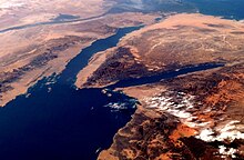
Gulf of Aqaba
At this northern end of the gulf are three important cities: Taba in Egypt, Eilat in Israel, and Aqaba in Jordan.
They are strategically important commercial ports and popular resorts for tourists seeking to enjoy the warm climate.
The International Hydrographic Organization defines the southern limit of the gulf as "A line running from Ràs al Fasma Southwesterly to Requin Island (27°57′N 34°36′E / 27.950°N 34.600°E / 27.950; 34.600) through Tiran Island to the Southwest point thereof and thence Westward on a parallel (27°54'N) to the coast of the Sinaï Peninsula".
[2] Trade across the Red Sea between Thebes' port of Elim and Elat at the head of the gulf is documented as early as the Fourth Dynasty of Egypt.
[citation needed] Thebes used Nubian gold or Nub from her conquests south into Kush to facilitate the purchase of frankincense, myrrh, bitumen, natron, juniper oil, linen, and copper amulets for the mummification industry at Karnak.
At the northern edge, the ancient city of Ayla (in present-day Aqaba) was a commercial hub for the Nabateans.
The Romans built the Via Traiana Nova, which joined the King's Highway at Aqaba and connected Africa to Asia and the Levant and Red Sea shipping.