1991 Halloween blizzard
The 1991 Halloween blizzard was a powerful storm that caused a period of heavy snowfall and ice accumulation, which affected parts of the Upper Midwest of the United States, from October 31 to November 4, 1991.
Arctic air that was pulled southward behind the storm had combined with the heavy snow pack to produce many record low temperatures.
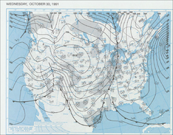
The 1991 Halloween Blizzard developed from a strong arctic cold front that pushed south and east through the central United States several days prior.
As an upper-level shortwave trough approached the Southern Plains, it aided the development of an area of surface low pressure along the sharp temperature gradient near the Texas Gulf Coast.
Cooler readings lingered at the very end of October across the Upper Midwest, and a re-enforcing pool of Arctic air was just beginning to push southeast through the western Canadian Provinces.
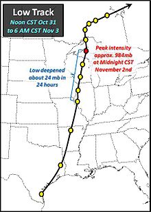
On November 1, the low-pressure system moved north from western Illinois into the Upper Peninsula of Michigan and the minimum pressure fell about 24 millibars in 24 hours, indicative of rapid deepening and strengthening of the cyclone.
The low pressure eventually became occluded, weakened, and then continued to dissipate as it pushed east across northern Ontario in subsequent days.
The heavy snow began falling across east central Minnesota and northwest Wisconsin during the late afternoon hours of October 31.
As the storm system pushed its way northward, more communities in eastern Minnesota and northwestern Wisconsin began to experience similar conditions; and thundersnow occurred as far north as Duluth.
[citation needed] Many roads were closed both from the snow and ice, including long stretches of I-90, I-35 and I-29 in Iowa, Minnesota and South Dakota.
November 1 saw similar daily records fall, but with a more wide reaching area from most of central Minnesota eastward to La Crosse and Eau Claire, Wisconsin.