Historic center of Genoa
[1] Had the architects who built Genoa had space, had they been able to indulge their imaginations unhindered by their whims, they could not have found the infinite resources and variety of motifs, designs, and arrangements that gave the façades of their palaces their original character, introducing the unexpected grandeur into every crevice.The history of the historic core of the Ligurian capital is totally linked to the city's history, from the beginnings of the construction of the first dwellings of the Ligurians on the hill of Castello, to the Roman period, along the years of the Maritime Republics (of which the annalist Caffaro di Rustico da Caschifellone, known simply as the Caffaro, kept note), to the patriotic and insurrectional battles of Young Italy and Giuseppe Mazzini's Carboneria.
[2] Reconstructions of past centuries did not always prove to be accurate in the light of new discoveries, and it often occurred that they contained errors, due to a lack of archaeological sources and/or an attempt to locate elements of the ancient city based on those, more modern, of Genoa visible at the time when these hypotheses were made.
[16] During excavations for the construction of the subway, a 12-meter-long dry-stone wall with nearby remains of hearths and a canal were found in the area adjacent to the Brignole train station, the origin of which would date back to a period between the 3rd and 2nd millennia BC.
[21] In January 2013, during archaeological inspections carried out along the nearby Spinola Bridge as part of the work related to the expansion of the Genoa Aquarium with a new dolphin tank, remains of vases and amphorae, both Etruscan and Roman, were found, some of them containing fruit stones, legumes and seeds.
[30] Finds that can be linked to the Etruscan presence also include a probable boundary stone, containing the Etruscan-language inscription mi nemetiés, identified in the area of the former convent of San Silvestro and dated around the first half of the fifth century B.C.
[36] The author and traveler Henry Aubert, in his essay Cities and People of Italy (Villes et gens d'Italie, published in Paris in 1923), provides a concise portrait of the historic center of a city-emporium, defined as nothing more than a marketplace with no political importance.
[35] The city of Genoa is featured in the Tabula Peutingeriana, a medieval reproduction of a Roman map, which showed the main routes of the Empire, and which is believed to have been compiled in later stages, probably starting in the second century B.C.
[56] According to reports two centuries later by Paul the Deacon in his Historia Langobardorum, at the same time as the descent of the Lombards into Italy, in the 670s, Liguria was struck by a plague, which caused numerous deaths and the abandonment of cities and pastures in the countryside as the inhabitants fled: —Paul the Deacon, Historia Langobardorum, volume 1[57]Between 641 and 643, the Lombard king Rothari conquered Liguria and assaulted, among others, the city of Genoa, sacking and burning some areas of it, and probably destroying the walls already present,[58] about whose actual existence, extent and position in this historical period, however, there is no shared opinion among scholars.
[84] Historian Federico Donaver, in his 1912 Le Vie di Genova, describes the area in medieval times as follows: In the Middle Ages, the most glorious expeditions of the Republic left from the port, which was the main landing place.
During the Battle of Meloria in August 1284, the Genoese fleet captured some 9,000 soldiers and sailors of the republic of Pisa, locking them up in an area located in the vicinity of the walls and harbor, which to this day bears the name of the Pisan camp.
Several buildings in the historic center incorporated architectural details that were the result of looting during the war, such as the lions of St. Mark found on the side of the church of San Marco al Molo and on the facade of Palazzo Marcantonio Giustiniani, both from Istrian Pula.
Between the end of the 14th and the 15th centuries, a real red-light district was created in Genoa, in the area where Castelletto (Monte Albano) is now located, in which prostitution (previously widespread in brothels distributed haphazardly in different parts of the city, not without friction with the ecclesiastical power) was strictly regulated.
[103] During this period (on 23 April 1407, to be precise)[104] the Bank of Saint George was founded, which had its headquarters in the palace of the same name: created at the behest of the city's French governor Jean II Le Maingre, it would remain in operation for about four centuries, until it was dissolved by Napoleon.
Foreign control over politics and constant internal struggles, however, did not put a brake on continued building growth and renovation of pre-existing areas, and in Via San Luca, then the main route from the center to the western edge of the city, the palaces of the Spinola, Grimaldi, Pinelli, and Lomellini families were built.
Jewish immigration to the city in these decades consisted largely of former merchants and traders who, in the new situation prevailing in the Iberian Peninsula under the reign of Ferdinand II of Aragon, who was adverse to the Jews, had seen much of their wealth disappear in a short time.
Symbolizing this period of growth in the Maddalena sestiere, on behalf of some of the leading noble Genoese families of the time (Spinola, Grimaldi, Lomellini, Pallavicini, Brignole Sale and Lercari), the Strada Nuova, today's Via Garibaldi, about 250 m long, with its stately palaces, was planned and then built, in which, starting in 1576,[113] the Rolli system was established.
From there the ghetto would move, in 1674, to Vico dei Tessitori[123] in an area close to the church of Sant'Agostino and the present-day Piazza delle Erbe, of which no trace remains, however, due to the Allied bombings of World War II, and was then abolished altogether in 1752.
[132] Initially the city resisted foreign forces and the French ships retreated once they ran out of ammunition, but the following year the Doge Francesco Maria Imperiale Lercari had to go with some senators to Versailles to offer the Republic's apologies to the Sun King:[133] a new phase of decline began for Genoa.
Its acquisition and subsequent demolition, to make way for the modernization of the area with the building of the upper part of Via XX Settembre, saw almost 30 years of bargaining (it was begun in 1876) between state and municipal institutions and the construction company, and only in 1904 was it finally torn down.
[142] Barabino connected the park with that of the villa, belonging to Marquis Gian Carlo Di Negro, carved out on the area where the 16th-century bastion of Luccoli stood, passing through what is now Piazza Luigi Emanuele Corvetto.
General Alfonso La Marmora, sent by the newly reigning Victor Emmanuel II to quell the uprising, ordered a naval bombardment, which mainly hit the Portoria district (severely damaging the Pammatone hospital) and the port, which was followed by a bloody intervention by the bersaglieri, who indulged in destruction and gratuitous violence against the population.
[165] Alfredo D'Andrade, an architect and archaeologist, first director of the Regional Office for the Preservation of Monuments of Piedmont and Liguria and later also representative of the Ministry of Education in the negotiations concerning the sale of the prisons (former Benedictine monastery) present on the hill of Sant'Andrea, for the subsequent demolition of the same, in his communications with the central government accused the City of Genoa and the private individuals interested in the construction of being driven by speculative motives, rather than by real reasons of hygiene and public utility.
Via del Campo, there’s a whorewith great big leaf-colored eyes.If the desire to love her comes to you,it’s enough to just take her by the hand.In 1907 a Department of Fine Arts, the first of its kind in Italy, was established by the municipality, initially headed by historian and archaeologist Gaetano Poggi, former mayor of Arquata Scrivia between 1890 and 1895 and a member of an earlier commission that was to assess which Genoese buildings and monuments should be subject to special protection because of their historical value.
[171] In May 1937, the architect and engineer Piero Barbieri published a study in the journal Genova titled Master Plan and Thinning of Medieval Genoa,[177] in which he analyzed the situation of the old city from both a demographic point of view (with also its repercussions related to public health issues) and a transportation point of view (also publishing his own research on the distribution of various pedestrian flows along the main routes), as well as of enhancement of buildings of artistic and historical interest, to be implemented mostly through the gutting of adjacent buildings to create squares that could make them more visible and noticeable.
These directions correspond, for the oldest part, to Via San Lorenzo, which descends, crossing numerous streets, alleys (the caruggi) and lateral creuze, from the Piano di Sant'Andrea and Piazza De Ferrari to the Marina and the old port.
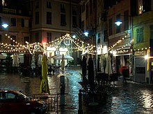
[192] As for the eastern part of the historic center, after years of semi-abandonment, the relocation of the faculty of architecture to Stradone Sant'Agostino/Via Mascherona[193] (which connects Sarzano/Castello with the caruggi sites between Piazza delle Erbe and Via San Lorenzo) with the rehabilitation of the area of the San Silvestro convent (destroyed by bombing) and the opening of numerous restaurants and clubs from the 1990s onward, have led to a rebirth of the area and to an active and busy evening and nightlife, the so-called Genoese "movida," which is, however, often a source of friction with part of the residents, who on several occasions have demanded and obtained from the public administration restrictive measures on the opening hours of clubs.
The palaces, often erected on sloping ground, divided into a sequence of atrium - courtyard - staircase - garden and rich in interior decoration, express a singular social and economic identity that inaugurated modern-age urban architecture in Europe.Genoa's historic center is home to the largest and among the best-known churches and buildings of worship in the city.
As for the formerly existing Islamic places of worship in the dock area, these were abandoned and used for other purposes at the end of the 18th century, when, in the wake of the ideals of the French Revolution, the newly formed Ligurian Republic abolished slavery, freeing the Muslim prisoners there.
The redefined palaces thus needed new entrances, more sumptuous than the previous ones, the design and construction of which were entrusted to sculptors and master masons, often from outside the city (many of whom came to Genoa because they were interested in the marble and other raw materials that were landed in the port), mainly from Lombardy (from the Intelvi Valley) or Tuscany.
The bureau analyzing the data from the 1871 census justified this decline by changes in the unstable population, by the cholera epidemic that had hit the city between 1866 and 1867, and by the fact that many citizens had moved to the more livable and inexpensive neighboring towns.