History of North Carolina
Findings of the earliest discovered human settlements in present day North Carolina, are found at the Hardaway Site, dating back to approximately 8000 BCE.
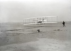
On December 17, 1903, Orville and Wilbur Wright successfully piloted the world's first powered heavier-than-air aircraft at Kill Devil Hills, in the Outer Banks of North Carolina.
During the late 19th and early 20th century, North Carolina would start its shift from mainly an agricultural based economy, to industrialization, adding many more new job occupations throughout the state.
The earliest discovered human settlements in what eventually became North Carolina are found at the Hardaway Site near the town of Badin in the south-central part of the state.
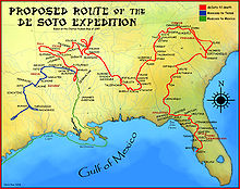
They appeared in West Virginia, driving the Tutelo east to live near the Saponi, then punched straight south, through the Chalaques, settled somewhere around the Yadkin River and began preying on the smaller Siouan tribes of the region.
Although broken and abandoned by the English colonists they were formerly allied to, the Yamasee people survived as backwater nomads throughout a vast territory between South Carolina and Florida.
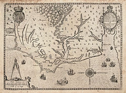
[19] The expedition made landfall at Cape Fear, and Verrazzano reported of his explorations to the King of France, "The seashore is completely covered with fine sand [15 feet] deep, which rises in the shape of small hills about fifty paces wide ...
In the ensuing years, wealthier settlers imported and purchased more slaves to develop plantations in the lowland areas, and the African proportion of the population rose rapidly.
Differences in the settlement patterns of eastern and western North Carolina, or the low country and uplands, affected the political, economic, and social life of the state from the 18th until the 20th century.
During the Revolutionary War, the English and Highland Scots of eastern North Carolina tended to have more loyalist towards the British Crown, because of longstanding business and personal connections with Great Britain.
The English, Welsh, Scots-Irish and German settlers of the western half of North Carolina, largely tended to favor American independence from Britain.
In a world sharply divided along lines of ethnicity, gender, race, and class, the tavern keepers' rum proved a solvent that mixed together all sorts of locals, as well as travelers.
The increasing variety of drinks on offer and the emergence of private clubs meeting in the taverns, showed that genteel culture was spreading from London to the periphery of the English colonial empire.
After the war, Colonel Leggett and some of his soldiers moved to Nova Scotia; the British gave them free land grants in County Harbour as compensation for their losses in the colony.
[53] Struggling with a weak tax base, state officials used impressment to seize food and supplies needed for the war effort, paying the farmers with promissory notes.
In mid-century, the state's rural and commercial areas were connected by the construction of a 129–mile (208 km) wooden plank road, known as a "farmer's railroad", from Fayetteville in the east to Bethania (northwest of Winston-Salem).
Planters owning large estates wielded significant political and socio-economic power in antebellum North Carolina, placing their interests above those of the generally non-slave holding "yeoman" farmers of the western part of the state.
The Union's naval blockade of Southern ports and the breakdown of the Confederate transportation system took a heavy toll on North Carolina residents, as did the runaway inflation of the war years.
Governor William W. Holden had used civil powers and spoken out to try to combat the Ku Klux Klan's increasing violence, which was used to suppress black and Republican voting.
Paramilitary groups such as the Red Shirts beginning in 1875, worked openly to disrupt black political meetings, intimidate leaders and directly challenge voters in campaigns and elections, especially in the Piedmont area.
Of mixed race and claiming Native American heritage, the families had been classified as free people of color in the antebellum years and did not want to send their children to public school classes with former slaves.
That year North Carolina's 2nd congressional district elected George Henry White, an educated African-American attorney, as its third black representative to Congress since the Civil War.
In 1898, in an election characterized by violence, fraud, and intimidation of black voters by Red Shirts, white Democrats regained control of the state legislature.
In 1899, the Democrat-dominated state legislature ratified a new constitution with a suffrage amendment, whose requirements for poll taxes, literacy tests, lengthier residency, and similar mechanisms disfranchised most blacks and many poor whites.
Without the ability to vote, they were excluded from juries and lost all chance at local offices: sheriffs, justices of the peace, jurors, county commissioners and school board members, which were the active site of government around the start of the 20th century.
White Southerners controlled a block of votes and important chairmanships in Congress because, although they had disfranchised the entire black population of the South, they had not lost any congressional apportionment.
The textile industry in the Piedmont region continued to attract cotton mills relocating from the North, where unions had been effective in gaining better wages and working conditions.
In the first half of the 20th century, other African Americans voted with their feet, moving in the Great Migration from rural areas to northern and midwestern cities where there were industrial jobs.
During World War II, Durham's Black newspaper, The Carolina Times, edited by Louis Austin, took the lead in promoting the "Double V" strategy among civil rights activists.
[103] Much of the growth in jobs and population increases happened in metropolitan areas of the Piedmont Crescent region, being in and around cities such as Charlotte, Raleigh, and Greensboro.