Hurricane Barry (2019)
The system eventually emerged into the Gulf of Mexico from the Florida Panhandle on July 10, whereupon the National Hurricane Center (NHC) designated it as a potential tropical cyclone.
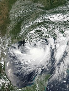
On July 13, Barry attained its peak intensity as Category 1 hurricane with 1-minute sustained winds of 75 mph (120 km/h) and a minimum central pressure of 993 millibars (29.3 inHg).
The storm finally degenerated into a remnant low over northern Arkansas on the same day, subsequently opening up into a trough on July 16.
In parts of the Northeastern United States and Ontario, Canada, severe thunderstorms from Barry's remnants caused an additional 160,000 power outages and spawned a few weak tornadoes.
The origins of Barry can be traced to a mesoscale convective vortex – a complex of thunderstorms – that formed over southwestern Kansas on July 2.
[5] By July 8, the NHC assessed a high probability of a tropical cyclone developing due to favorable conditions in the Gulf.
[8] On July 9, a broad area of low pressure exited the Florida Panhandle and tracked into the northeastern Gulf of Mexico, accompanied by scattered convection.
[9] At 00:00 UTC on July 11, the system developed into a tropical depression about 200 mi (320 km) south of Mobile, Alabama.
The depression intensified into Tropical Storm Barry six hours later as the convection had increased to the south of the system's circulation.
[5] The storm's convection organized into a large rainband south of an elongated circulation,[10] though mid-level dry air and northerly wind shear prevented thunderstorms from forming near the center.
[11][5] On July 12, data from two hurricane hunter reconnaissance aircraft found that Barry had quickly intensified, with its central pressure dropping.
[12] Due to a slight decrease in shear on the morning of July 13, the storm's outflow expanded and the banding increased.
[14] Barry attained Category 1 hurricane status by 12:00 UTC that day, with a small area of hurricane-force winds occurring east of the center.
[16] Barry was one of four hurricanes to hit Louisiana at Category 1 intensity in the month of July, the others being Bob in 1979, Danny in 1997, and Cindy in 2005.
[21] The United States Army Corps of Engineers feared that levees would be overtopped in Plaquemines Parish by storm surge and historically high river levels.
[26] New Orleans Mayor LaToya Cantrell urged residents to "shelter in place" but did not order evacuations, citing Category 3 status as the threshold.
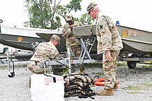
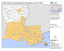
After declaring a state of emergency and deploying search and rescue assets,[28] Louisiana Governor John Bel Edwards requested a federal disaster declaration for the entire state on July 11, citing the potential for widespread flooding;[29] the request was granted by President Donald Trump later that day.
[33] Airbnb activated its Open Homes program, which provides temporary housing to evacuees or storm victims, for parts of Texas, Louisiana, Mississippi, and Alabama.
[27] The highest storm surge in Louisiana was 6.13 ft (1.87 m) above normal tide levels at Eugene Island in Atchafalaya Bay.
[44] The Lower Dularge East Levee in Terrebonne Parish was overtopped, prompting a mandatory evacuation for nearby areas.
[45] On the afternoon of July 12, Louisiana Highway 1 south of Golden Meadow was closed after seawater began to inundate portions of the road, cutting off access to Grand Isle and Port Fourchon.
[63] Floodwaters from coastal flooding reached several feet deep in some locations, causing beach erosion and leaving behind 3 ft (0.91 m) of sand on Bienville Boulevard on Dauphin Island.
[67] Along the Florida Panhandle, beaches issued warnings to the public to stay out of the water to avoid rip currents and dangerous swimming conditions; however, there were still many calls of swimmers in distress.
In Panama City Beach, multiple people formed a human chain in an effort to save swimmers who had gotten caught in a rip current caused by the storm.
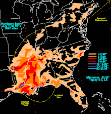
[69] A rainfall total of 16.59 in (421 mm) was recorded near the city, making Barry the wettest tropical cyclone in state history.
[73] In the Northeastern United States, Barry worsened a heat wave due to the tropical air mass it brought along with it.
[18] Barry's remnant moisture brought severe thunderstorms to the region from July 16–17, causing downed trees and power outages.
[51] More than 2.4 in (60 mm) of rain fell in Toronto, Canada, on July 17, as the post-tropical cyclone moved just south of the area, resulting in street-level flash flooding and the blockage of a ramp to Ontario Highway 401, where several cars were submerged.
The Bureau of Safety and Environmental Enforcement asserted that Barry caused nearly 73% of crude oil production in the Gulf to shut on July 15, two days after the storm made landfall.
[47] From July 25 to August 8, FEMA, along with state and local governments conducted Preliminary Damage Assessments in Louisiana.

Tropical storm (39–73 mph, 63–118 km/h)
Category 1 (74–95 mph, 119–153 km/h)
Category 2 (96–110 mph, 154–177 km/h)
Category 3 (111–129 mph, 178–208 km/h)
Category 4 (130–156 mph, 209–251 km/h)
Category 5 (≥157 mph, ≥252 km/h)
Unknown