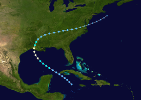
Hurricane Danny (1985)
The fourth named storm and third hurricane of the season, Danny developed from a tropical wave in the northwestern Caribbean Sea on August 12.
A combination of rainfall and storm surge in southern Mississippi caused severe beach erosion and flooded 70 homes in Hancock County alone.
Two days later, a United States Air Force reconnaissance aircraft observed a poorly-defined circulation near the Cayman Islands with enough organization to be designated Tropical Depression Four.
The nascent depression moved northwestward without further organization, crossing over western Cuba near Cape San Antonio early on August 13.
After crossing Cuba into the Gulf of Mexico, the depression organized more and intensified into Tropical Storm Danny early on August 14.
[1][2] Intensifying over the open waters of the Gulf of Mexico, Danny attained hurricane status around 00:00 UTC on August 15, only 24 hours after being upgraded to a tropical storm.
[1][3] Danny remained a distinct tropical entity as it progressed into the Tennessee Valley on August 17, its circulation drawing in drier air from the northwest.
These weather conditions caused a tornado outbreak, due to the atmospheric instability and high convective available potential energy.
The remnants of Danny continued to the east-northeast, emerging into the western Atlantic Ocean near the Eastern Shore of Virginia, and were tracked until August 20 to the southeast of Nantucket.
[1][3][2] Prior to the arrival of Danny, a gale warning and a hurricane watch was issued from the upper-Texas coast to Mobile on August 13.
Along the coast, storm tides destroyed a $5,000 pier, while low-lying roads in Madisonville and Mandeville were closed due to inundation.
In Plaquemines Parish, 3 to 4 ft (0.91 to 1.22 m) of storm tides flooded areas along the Mississippi River and outside of the levee system from Empire southward.
Storm surge also damaged several homes and fishing camps in the cities of Galliano, Golden Meadow, Leeville, and Port Fourchon in Lafourche Parish.
[11] A Coast Guard helicopter had to evacuate 7 Texans who were on a yacht in the Gulf of Mexico forty miles offshore, since their radio was broken and they were therefore unaware they were sailing into the storm.
In Iberia Parish, storm surge heights ranging from 5 to 6 ft (1.5 to 1.8 m) inundated barrier islands and coastal marshes, resulting in about $2 million in damage to houses, businesses, and fishing camps.
Wind also de-roofed houses and destroyed mobile homes in the cities of Gueydan and Kaplan, while numerous trees were uprooted.
Moderate storm surge damage was reported in some areas near the mouth of the Mermentau River, in the Rockefeller Wildlife Refuge, and the community of Chenier Au Tigre.
Strong winds in Allen Parish caused large oaks trees fall on a home and a trailer in Kinder, Louisiana.
Strong winds in St. Martin Parish also felled trees, which struck a church and homes in Breaux Bridge and St. Martinville.
The tornado moved northward just east of downtown and caused extensive damage to an auto parts store and two mobile home sales parks along Route 78.
The tornado reached the Muscle Shoals area before lifting, where it primarily impacted trees and power lines, though some buildings suffered roof damage.
The tornado damaged or destroyed numerous homes and buildings along its 45 mi (72 km) path, especially over western Limestone County.
The next tornado touched down in Birmingham near Interstate 459, causing damage to at least one home after trees fell on Alton Road.
The next tornado touched down in Lauderdale County near State Route 20 and Natchez Trace Parkway, causing little damage.
Another tornado was spawned in Cullman County, moving from just north of Hanceville to just east of Berlin, damaging some buildings before lifting.
Tides of 2 to 3 ft (0.61 to 0.91 m) above normal caused only minor beach erosion, though State Highway 87 was temporarily closed between Sabine Pass and High Island due to sand and debris washed onto the road.
Light rainfall was reported in the state, peaking at 1.85 inches (47 mm) in Bon Weir, which is located in extreme eastern Newton County.
Flooding was reported along the south coast of the state, due to rainfall amounts reaching 5 inches (130 mm), high tides, and waves about 2 ft (0.61 m) above normal.
The tornado ended after impacting the Jackson County Airport, where it destroyed 13 aircraft and severely damaged and unroofed a hangar.
[6] A frontal boundary, which combined with the remnants of Danny, brought heavy rainfall to the Roanoke Valley region of Virginia.
Tropical storm (39–73 mph, 63–118 km/h)
Category 1 (74–95 mph, 119–153 km/h)
Category 2 (96–110 mph, 154–177 km/h)
Category 3 (111–129 mph, 178–208 km/h)
Category 4 (130–156 mph, 209–251 km/h)
Category 5 (≥157 mph, ≥252 km/h)
Unknown

