Hurricane Fefa
The system produced rough surf, moderate wind gusts, and locally heavy rainfall during its passage over Hawaii.
It continued to organize, and subsequent to the development of a low-level circulation it formed into Tropical Depression Seven-E while located about 975 miles (1,569 km) south-southeast of Cabo San Lucas on July 29.
[1] Operationally, tropical cyclone advisories were not initiated until visible satellite images confirmed the low-level circulation twelve hours after the depression formed.
[2] Located over warm waters with fair upper-level outflow,[2] the depression quickly intensified and attained tropical storm status twelve hours after forming.
[3] Fefa initially strengthened slowly; on the day after it became a tropical storm the center was located on the western edge of the deep convection.
[4] On July 31, convection began increasing over the center,[5] and it is estimated it intensified into a hurricane later that day while located about 710 miles (1,140 km) southwest of the southern tip of Baja California.
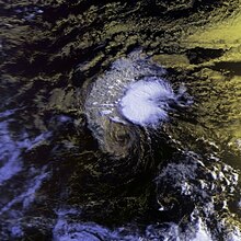
[7] On August 2, the eye organized further, and Fefa strengthened to attain a peak intensity of 120 mph (190 km/h) while located about 940 miles (1,510 km) west-southwest of Cabo San Lucas.
[11] Despite moving over marginally warm sea surface temperatures and becoming involved with the Stratocumulus cloud field to its north, the hurricane restrengthened on August 4[12] to reach a secondary peak intensity of 105 mph (169 km/h) while located about 1,265 miles (2,036 km) east-southeast of Hilo, Hawai'i.
[13] Prior to moving across the island of Hawaii, strong thunderstorms developed in the northeastern portion of the remnant circulation of Fefa.

Tropical storm (39–73 mph, 63–118 km/h)
Category 1 (74–95 mph, 119–153 km/h)
Category 2 (96–110 mph, 154–177 km/h)
Category 3 (111–129 mph, 178–208 km/h)
Category 4 (130–156 mph, 209–251 km/h)
Category 5 (≥157 mph, ≥252 km/h)
Unknown