2023 Pacific hurricane season
In August, Category 4 Hurricane Dora passed south of the Hawaiian Islands and contributed to strong gradient winds over Hawaii, which in turn helped fan the flames of multiple devastating wildfires.
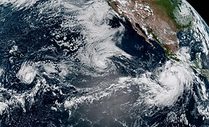
[3] Later that month, Hurricane Hilary made landfall as a tropical storm in Baja California, later bringing torrential rainfall and gusty winds to the Southwestern United States.
The above-average activity levels were largely attributed to the strong El Niño event, which brought anomalously high sea surface temperatures and low vertical wind shear to western parts of the basin.
[19] On August 11, Dora crossed the International Dateline, becoming the second tropical cyclone on record to be at hurricane strength in the Eastern, Central and Western Pacific basins, the other being John in 1994.
Papaya trees were strewn across the ground from their plantations, while the tile and tin roofs of hundreds of houses were severely damaged or destroyed, particularly in the small town of Maruata.
[52] Still moving generally westward, the storm crossed the 140th meridian at around 15:00 UTC on July 17, thus entering the central Pacific basin; its sustained winds at the time were near 50 mph (85 km/h).
Moving northwestward toward the southern tip of the Baja California peninsula under favorable conditions, the system began to rapidly intensify, becoming Tropical Storm Eugene six hours later, and attaining peak sustained winds of 70 mph (110 km/h) at 12:00 UTC on August 6.
[77] Later, Eugene moved over cold water west of the Baja California peninsula where its diminishing thunderstorm activity ceased, and it transitioned into a post-tropical cyclone on the afternoon of August 7.
[80] A well-defined center of circulation was observed within the disturbance on the afternoon of August 12, marking the formation of Tropical Depression Seven-E in the open ocean south-southwest of the Baja California peninsula.
[82] Into the next day, Fernanda followed a west-northwestward course, and was displaying signs that it was intensifying, including, very cold central dense overcast cloud tops of near −112 °F (−80 °C), and a well defined upper-level outflow over the western half of its circulation.
[94] The storm strengthened some on August 15, as an inner core developed and deep convection increased near its center, a result of diminished wind shear and continued warm water temperatures.
[99] The disturbance gradually became better organized during the following day, and when a well-defined circulation along with developing convective banding features were observed on the morning of August 16, it was classified as Tropical Storm Hilary by the NHC.
[117] Irwin remained a poorly organized storm, struggling to generate sustained convection in account of increasingly cooler water temperatures and low relative humidity.
[130] On September 11, the NHC began monitoring a disorganized area of showers and thunderstorms associated with a tropical wave far southwest of the Baja California peninsula,[131] that initially left the west coast of Africa two weeks earlier on August 26.
[135] Its structure degraded the following morning,[136] and persistent deep convection ceased, resulting in the system degenerating into a post tropical remnant low early on September 18.
[137] Showers and thunderstorms within the low pressure area became more persistent over the ensuing couple days, and better organized by the morning of September 19, resulting in the formation of Tropical Depression Thirteen‑E.
[138] Moving west that afternoon amid warm sea surface temperatures and favorable atmospheric conditions, the depression was able to strengthen somewhat, and became Tropical Storm Kenneth.
[141] After maintaining its strength for another day, Kenneth began to weaken on September 21 in the face of increasing southwesterly vertical wind shear, causing the storm's convection to wane.
[148] Fourteen-E continued to weaken in a fairly hostile environment, characterized by dry air and moderate wind shear, and it degenerated to a remnant low by 00:00 UTC on September 25.
[151] The low-pressure area further organized, with satellite and scatterometer data later showing the system had developed a well-defined closed circulation and was producing tropical storm-force winds.
Even though Lidia became a little stronger, the most intense deep convection was limited to the western part of the system's circulation on account of persistent easterly wind shear.
[158] Later, as environmental conditions became increasingly conducive for strengthening, Lidia explosively intensified to Category 4 strength by 21:30 UTC the next day,[159] and accelerated, while being steered to the east-northeast by a nearby mid- to upper-level trough.
[162] One person was killed north of Puerto Vallarta after strong winds caused by Lidia downed a tree on a van,[163] and two others were injured in Autlán de Navarro and Cihuatlán in Jalisco.
[174] The showers and thunderstorms associated with the disturbance gradually became better organized as it moved parallel with the southwestern coast of Mexico, and by the afternoon of October 17, had developed enough to be classified as Tropical Storm Norma.
[177] Later, moderate wind shear caused the system to weaken below major hurricane strength as it approached the southern end of the Baja California peninsula on the morning of October 21.
[180] There, strong wind shear enabled dry mid-level air to penetrate the circulation from the northwest, weakening the system to a tropical depression as it approached the coast of Sinaloa.
[9] Otis slightly weakened before making landfall near Acapulco at 06:45 UTC on October 25, as a Category 5 hurricane with winds of 160 mph (260 km/h) and a central pressure of 929 mb (27.43 inHg).
The system moved quickly west-southwestward the following day, weakening along the way due to an influx of drier air brought about by the Gulf of Tehuantepec gap-wind flow it was embedded within.
[196] Heavy rainfall from Pilar inundated parts of El Salvador, Honduras, and Guatemala, flooding several rivers, which caused damage to homes, infrastructure, and crops.
[190] On November 16, a small area of low pressure producing some disorganized showers and thunderstorms formed about 1,000 mi (1,610 km) south-southwest of the southern tip of the Baja California Peninsula.