Hurricane Hilary
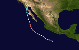
The hurricane underwent rapid intensification, reaching maximum sustained winds of 140 mph (220 km/h) and a central pressure of 940 mbar (27.76 inHg) on August 18, making it a Category 4 on the Saffir-Simpson scale.
After environmental conditions became unfavorable, Hilary weakened as it approached land, making landfall on August 20 as a tropical storm in San Quintín along the western Baja California peninsula.
In anticipation of "catastrophic and life-threatening flooding", the National Hurricane Center (NHC) issued its first-ever tropical storm warning for Southern California, extending from the Mexico–United States border to just north of Los Angeles.
[1] The tropical wave crossed Central America into the far eastern Pacific Ocean on August 12, producing a large area of disorganized convection, or thunderstorms.
[1][2] As early as August 13, hurricane prediction models anticipated a tropical cyclone would affect Mexico and the southwestern United States.
After a low-level circulation formed early on August 16, the system developed into a tropical depression by 06:00 UTC, located about 345 mi (555 km) south of Acapulco.
Atmospheric and environmental conditions were conducive for further strengthening, including warm sea surface temperatures of near 86 °F (30 °C), ample moisture, and low wind shear.
[7] At 06:00 UTC that day, the NHC estimated that Hilary attained a peak intensity of 140 mph (220 km/h), making it a Category 4 hurricane, while its barometric pressure dropped to 940 mbar (28 inHg).
At around 17:00 UTC that day, Hilary made landfall in a sparsely populated region of northwestern Mexico in the state of Baja California, with sustained winds estimated at 60 mph (95 km/h).
[11] The combined system, which included the remnants of Hilary, continued moving through the western United States and eventually crossed into Canada.
[12][13] The Mexican government first issued tropical storm watches for southern Baja California Sur on August 17, upgrading them to warnings later that day.
The Los Angeles County Sheriff's Department advised all people to leave Catalina Island on August 19, while Avalon Bay was closed to boats and ships.
[59][60] Amtrak also truncated the August 19 runs of westbound Southwest Chief and the southbound Coast Starlight to Albuquerque, New Mexico, and Emeryville, California, respectively.
[65] A Falcon 9 launch carrying Starlink satellites from Vandenberg Space Force Base in Santa Barbara County was postponed by SpaceX.
[73] In addition, no live audience was permitted to attend the August 20 games for VALORANT Champions Los Angeles at the Shrine Auditorium and Expo Hall.
One occurred in Santa Rosalía in Baja California Sur, when floodwaters breached a protection wall, sweeping away a vehicle, with four of the occupants rescued.
Closer to sea level, wind gusts reached 69 mph (111 km/h) at Loreto International Airport along the peninsula's eastern coast.
Tropical storm-force winds extended into the state of Sonora, where Mar de Cortés International Airport in Puerto Peñasco recorded gusts of 66 mph (105 km/h).
[21] In Los Cabos at the southern end of the peninsula, the hurricane caused minor damage to utilities and roads, including potholes.
[43][44][114][115] A nearly 30 mi (48 km) stretch of I-10 closed for two days from the floods, mud, and debris, which stranded hundreds of vehicles, and made it difficult to travel to Palm Springs.
[126] Farther north, heavy rain produced mudslides and flash flooding in Siskiyou County near Mount Shasta, damaging roads and drains.
[143] Across the Imperial Valley, high winds downed trees and power poles, as well as damaging a gas station canopy in El Centro.
[144] The storm spawned a microburst in Fresno, producing winds of 55 mph (89 km/h), which knocked down 50 trees at the Belmont Country Club.
[148][109] However, records for wettest (total rainfall) tropical cyclones and their remnants were broken in four states: Idaho, Montana, Nevada, and Oregon.
In a mountainous area near Mount Charleston, in Clark County, Nevada, wind gusts reached 82 mph (132 km/h), strong enough to knock down a few trees.
The damage, estimated at $35 million, closed the recreation area until October 26, when Nevada State Route 156 (Lee Canyon Road) was reopened.
[160] In Death Valley National Park, workers began clearing and assessing the damaged roads and infrastructure after the rains ended.
[124][162] Following heavy rainfall in Death Valley, floodwaters reformed the ancient Lake Manly in the usually dry Badwater Basin, lasting several months.
[129][166] On October 5, the U.S. Department of Transportation’s Federal Highway Administration announced the release of $15.3 million in emergency funds to help rebuild roads and bridges in 12 California counties.
[167] On November 22, President Biden announced a major disaster declaration for five California counties affected by the storm: Imperial, Inyo, Kern, Riverside and Siskiyou.
Tropical storm (39–73 mph, 63–118 km/h)
Category 1 (74–95 mph, 119–153 km/h)
Category 2 (96–110 mph, 154–177 km/h)
Category 3 (111–129 mph, 178–208 km/h)
Category 4 (130–156 mph, 209–251 km/h)
Category 5 (≥157 mph, ≥252 km/h)
Unknown


