2006 Atlantic hurricane season
[2] The season began on June 10 with the formation of Tropical Storm Alberto, which moved from the Caribbean Sea through the east coast of the United States.
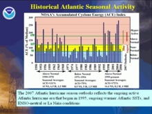
[3][4] On December 5, 2005, Klotzbach's team issued its initial extended-range forecast for the 2006 season, predicting an above average of 17 named storms, nine of them hurricanes, and five classified as Category 3 intensity or higher.
The sea-level pressure and trade wind strength in the tropical Atlantic were reported to be above normal, while sea surface temperature anomalies were on a decreasing trend.
The reduction was attributed to less favorable environmental conditions, a decrease in La Niña conditions, and the lack of a "very persistent upper-level ridge pattern over the eastern U.S. and western Atlantic"[10] On September 1, Klotzbach's team also revised its season estimate, to 13 named storms, 5 hurricanes, and 2 major hurricanes, citing a larger volume of the Saharan Air Layer and an El Niño trend in the Pacific.
Zeta joined Hurricane Alice as only the second North Atlantic tropical cyclone in recorded history to span two calendar years.
[14] Ten days into the start of the season, Tropical Storm Alberto developed in the Caribbean,[15] and after four months of activity, Hurricane Isaac dissipated on October 3 south of Newfoundland.
While the NHC did not operationally classify it, data from reconnaissance aircraft, NEXRAD weather radar, and surface observations suggest it may have met the criteria for a tropical cyclone.
[2] Because of several factors, including a rapidly forming El Niño event, the Saharan Air Layer over the tropical Atlantic and the presence of a high-pressure area to the Azores High situated near Bermuda, it contributed to a below average season.
[19] Southwesterly vertical wind shear initially prevented significant development, but as it moved closer to Florida, the depression strengthened into a tropical storm on June 11.
Passing over the warm, deep water of the Loop Current allowed accelerated development, and the cyclone reached its peak winds of 70 mph (110 km/h), just shy of hurricane strength.
Subsequent weakening occurred as it moved over the cooler waters of the continental shelf, and Alberto made landfall near Adams Beach, Florida, on June 14 with winds of about 45 mph (72 km/h).
The remnants tracked off the U.S. East Coast and transitioned into a powerful extratropical storm which affected Nova Scotia with high winds, heavy rain, and rough surf, leaving four fisherman missing offshore.
[29] The southern area near North Carolina became Tropical Storm Beryl,[30] and the northern system became an extratropical low on July 16, south-southeast of Cape Cod, Massachusetts.
Convection developed near the center, and the system transitioned into a tropical depression early on July 17, about 240 miles (390 km) southeast of Nantucket, Massachusetts.
Banding features became prominent, and after continued strengthening, the storm attained peak winds of 50 mph (80 km/h) late on July 17, while located about 245 miles (394 km) south of Halifax, Nova Scotia.
However, a post-season analysis provided enough evidence of tropical characteristics, indicating no frontal features and no cold air intrusion at the time of peak winds.
[17][31] The system was broad and ill-defined at first,[32] although the low-level circulation became sufficiently organized to be designated a tropical depression on July 18, about 290 mi (465 km) east-southeast of the coast of North Carolina.
Later that day, the depression developed organized rainbands over the eastern periphery of the circulation, and as a result, the NHC upgraded it to Tropical Storm Beryl.
The nascent storm moved generally northward at first along the western periphery of a subtropical ridge, parallel to the East Coast of the United States.
[34] Waves along the southern coast of Nantucket reached 10 feet (3.0 m) in height as the storm approached the island,[35] resulting in four people being rescued by lifeguards from rip currents.
The depression tracked westward and soon intensified into Tropical Storm Chris before reaching peak winds of 65 mph (105 km/h) northeast of the United States Virgin Islands.
[46] Soon after, southerly wind shear displaced the convection to the north of the center,[47] causing Debby to weaken into a tropical depression the next day.
However, Ernesto moved much farther east than anticipated, and made landfall as a tropical storm on the southern tip of Florida on August 29.
With a disorganized structure and multiple circulation centers, Florence remained a weak tropical storm for several days, even after external conditions became favorable for strengthening.
Florence then brought heavy rains across Newfoundland as an extratropical storm, destroying one house and causing minor damage to several others.
The convection increased and organized further, leading to the development of a tropical depression on September 12, located 270 mi (370 km) south-southeast of the Cape Verde Islands.
[59] A day later, as wind shear decreased, Helene began intensifying, reaching hurricane intensity on September 16, as it developed a ragged eye in the center of the convection.
[59][60][61] On September 17, the intensification became more rapid and Helene quickly became a Category 2 hurricane that morning as the eye became clearer and surrounded by deep convection.
[64] A day later, Helene turned back to the north and later northeast ahead of a trough that exited the east coast of the United States.
In addition, mid- to upper-level dry air had become entrained into the circulation, and the storm contained some subtropical characteristics with a baroclinic-type cloud pattern.