Hurricane Gordon (2006)
It gradually matured into a hurricane as it tracked northward, reaching its peak intensity with winds of 195 km/h (121 mph) early on September 14 while located about 925 km (575 mi) southeast of Bermuda.
The only land area affected while Gordon was tropical – the Azores – sustained little damage, in spite of wind gusts' reaching hurricane force on Santa Maria Island.
[1] The United States National Hurricane Center (NHC) first pinpointed the system as an area for potential development late on September 2 while it was about 1,210 km (750 mi) west-southwest of Cape Verde.
[1] However, on September 5, the NHC noted the potential for the storm system to organize into a tropical depression within the next several days,[3] but its close proximity to Florence continued to stall its strengthening.
Initially, the NHC faced difficulties in forecasting the future of the system due to the potential for resumed strong wind shear, as well as uncertainty in its path of direction.
[5] It gradually organized and intensified, and based on observations from the Hurricane Hunters, the NHC assessed the depression as a tropical storm late on September 11; upon doing so, they named it Gordon.
[9] On September 15, the trough that was previously guiding the hurricane moved farther away, allowing the ridge to build to the north and causing Gordon's motion to become nearly stationary.
[1] Despite continued forecasts of a weakening trend, Gordon's resiliency presented a rare threat – the first since Hurricane Charley in 1992 – to the Azores, a Portuguese archipelago in the northeast Atlantic Ocean.
[11] Shortly thereafter, Gordon began steadily weakening due to the combination of increasing wind shear and even cooler water temperatures.
Early on September 21, it completed the transition into an extratropical storm while simultaneously weakening below hurricane-force, located about 443 km (275 mi) west-northwest of the west coast of Portugal.
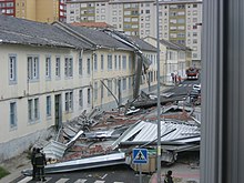
The cyclone maintained its identity as the system turned sharply northeastward and later northward, after passing about 160 km (99 mi) northwest of the Spanish province of Galicia.
When it became apparent that Gordon would continue intensifying, a hurricane warning replaced the watch about 27 hours before the strongest winds affected the region.
[1] In Portugal, coastal regions were put under a yellow alert, the second lowest level, since the extratropical remnants of Gordon were expected to produce rough seas and heavy rains.
Along the coast, waves reached 7 m (23 ft) in height, while rainbands dropped heavy precipitation, including a total of 65.5 mm (2.58 in) in Canfranc.
[28] Wind-blown debris injured four people in the country,[1] and a fifth storm-related injury occurred as the result of a tree falling onto an occupied vehicle.
[29] Stormy conditions threatened to affect the 2006 Ryder Cup in Straffan, County Kildare, Ireland at the K Club, and September 25 was set aside as an additional "reserve day".
[1] The storm interfered with an archaeological excavation undertaken by Time Team at Mount Murray on the Isle of Man, which was broadcast as part of the first episode of the 14th series.

Tropical storm (39–73 mph, 63–118 km/h)
Category 1 (74–95 mph, 119–153 km/h)
Category 2 (96–110 mph, 154–177 km/h)
Category 3 (111–129 mph, 178–208 km/h)
Category 4 (130–156 mph, 209–251 km/h)
Category 5 (≥157 mph, ≥252 km/h)
Unknown