2020 Pacific hurricane season
Amanda developed near Central America in late May and struck Guatemala, causing widespread damage in neighboring El Salvador and killing 40 people amid the COVID-19 pandemic in the latter country.
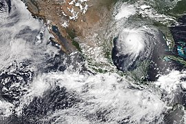
Genevieve passed closely to the tip of the Baja California Peninsula in August, bringing hurricane-force winds and heavy rainfall, killing six and causing an estimated $50 million in damage.
In late July, Hurricane Douglas made an extremely close pass to Hawaii, with its weak southern eyewall crossing Oahu, causing minor effects.
Tropical Storm Hernan moved very near the coast of southwestern Mexico, causing an additional fatality and several millions of dollars worth of damage.
Factors they expected to reduce activity were near- or below-average sea surface temperatures across the eastern Pacific and the El Niño–Southern Oscillation remaining in the neutral phase, with the possibility of a La Niña developing.
A disturbance developed within the Intertropical Convergence Zone (ITCZ) on April 17, aided by the passage of a convectively-coupled kelvin wave (CCKW) – an eastward-propagating area of enhanced thunderstorm activity near the equator.
The disturbance moved westward within the ITCZ over the next several days, and after developing a well-defined center and organized convection, it was designated as Tropical Depression One-E at 06:00 UTC on April 25 about 805 mi (1,295 km) southwest of Baja California Sur.
The conglomeration of these features led to the formation of a tropical depression around 18:00 UTC on May 30; it was positioned about 115 mi (185 km) south of Puerto San José, Escuintla.
Moving northeastward around the periphery of a large cyclonic gyre over northern Central America, the compact depression continued to organize, strengthening into Tropical Storm Amanda at 06:00 UTC the next day.
[24] The interaction between a tropical wave, a preexisting area of disturbed weather, and the favorable phase of the Madden-Julian Oscillation (MJO) led to the formation of a surface low late on June 23.
The system paralleled the Mexican coastline and only slowly organized over the coming days, eventually meeting the criteria to be designated a tropical depression around 18:00 UTC on June 29.
[27] A tropical wave emerged off the west coast of Africa on June 20 and crossed into the East Pacific on July 3, where it interacted with the monsoon trough and began to organize.
[29] However, Cristina instead encountered cooler waters and eventually drier air; it reached its peak intensity late on July 10 with winds of 70 mph (110 km/h) as it passed west of Socorro Island.
However, a post-season review of satellite wind data revealed that it briefly became a 40 mph (65 km/h) tropical storm around the time it displayed a well-defined rainband in its western quadrant.
[33] Increasing wind shear caused the hurricane to rapidly unfold on July 28, resulting in its degradation to a remnant low at 12:00 UTC the next day well to the southeast of Midway Atoll.
An eye developed within the storm's compact and symmetrical central dense overcast, and Elida reached peak winds of 105 mph (165 km/h) by 12:00 UTC the next morning.
Ultimately, the influence of dry air and cooler waters caused the storm to swiftly weaken, and it degenerated to a remnant area of low pressure by 00:00 UTC on August 13 while positioned west of Baja California Sur.
[48] A sinkhole shut down a portion of Mexican Federal Highway 80 between Santa Cruz and San Patricio, a mudslide closed down another part of the freeway near Lázaro Cárdenas.
[53] Despite Hernan weakening into a tropical depression before landfall in Baja California Sur, local weather services in the area advised residents to take extreme precautions.
[55] Within the broad cyclonic circulation across Central America and adjacent waters, a westward-moving tropical wave spawned an area of low pressure on August 23.
The new storm moved unusually quick toward the west-northwest and reached peak winds of 45 mph (75 km/h) on September 6 when a concentrated burst of thunderstorms developed over its center.
Ocean waters eventually began to decrease, causing a weakening trend that resulted in Karina's degeneration to a remnant low at 18:00 UTC on September 16.
Hostile wind shear initially prevented the depression from intensifying, but it lessened somewhat on September 21, allowing the system to become Tropical Storm Lowell around 18:00 UTC that day.
The nascent storm moved through an environment of warm ocean waters, abundant moisture, and decreasing northeasterly wind shear which facilitated its rapid organization.
Inner core processes modulated Marie's strength for a time, but it eventually crossed into cooler waters, drier air, and higher southwesterly wind shear.
A brief burst of convection nudged the low northward on October 7, but the cyclone curved west-southwest and opened up into a trough three days later, just after crossing into the Central Pacific.
By 18:00 UTC on November 3, the NHC determined the system was sufficiently organized to be designated Tropical Storm Odalys while it was centered about 730 mi (1,175 km) southwest of Baja California Sur.
[62] The season's final storm developed from an area of convection within the monsoon trough that may have been enhanced by a Gulf of Tehuantepec gap wind event over preceding days.
Both the low and associated thunderstorm activity gained cohesion over the coming days, resulting in the formation of a tropical depression around 18:00 UTC on November 17 to the southwest of Baja California Sur.
By 18:00 UTC that day, the cyclone degenerated to a remnant area of low pressure that moved west and then west-southwest prior to dissipating into an open trough on November 21.