Tropical cyclones in 2020
[2][3][4] As 2020 began, sea surface temperatures were above normal in the eastern Pacific Ocean near the equator, which had the potential to develop into El Niño conditions.
[6] However, the sea surface temperatures near the equatorial pacific began to cool well below average, indicating a developing La Niña.
[7] In September, NOAA confirmed that the environment shifted to a La Niña pattern, based on lower than normal water temperatures in the eastern Pacific Ocean near the equator.
The ENSO Blog estimated a 75% chance that La Niña conditions would persist through the end of the year, in part due to a strengthening Walker circulation.
However, they began to warm up significantly that Spring, with the Caribbean, Gulf of Mexico and the Main Development Region all having well above-average sea surface temperatures.
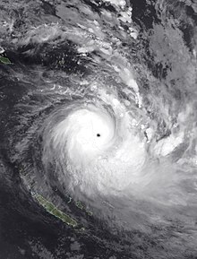
In the South Pacific island nation of Vanuatu, COVID-19, travel and social distancing restrictions associated with the pandemic were lifted for those seeking safe houses and evacuation shelters during Cyclone Harold.
[15] Movement restrictions in El Salvador were temporarily lifted to allow people to purchase supplies ahead of Tropical Storm Amanda.
After fifteen years, the 2020 Atlantic hurricane season has surpassed record high activity in terms of named storms.
Iota was also the strongest storm in terms of wind speed, peaking with a strength of 155 mph or as a Category 4 hurricane on the Saffir–Simpson scale.
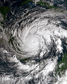
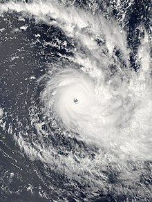
The strongest storm in the basin this year was Hurricane Marie, which reached low-end Category 4 strength on the Saffir–Simpson scale and it did not impact land.
It exited the basin on November 30 and entered the South West Indian Ocean where it intensified into a severe tropical storm and it was named Bongoyo.
In early February, another low originally in the Australian region crossed the 160th meridian east and emerged in the South Pacific.
During December 8, the FMS reported that Tropical Disturbance 01F had developed, while it was located about 145 km (90 mi) to the northeast of Apia in Samoa.
Yasa peaked with a minimum barometric pressure of 917 mb (27.08 inHg) and maximum wind speed of 230 km/h (145 mph), while Zazu dissipated into an extratropical cyclone.
Damien became the first and strongest storm of the month, impacting the Pilbara region of Western Australia as a Category 2 tropical cyclone on the Saffir–Simpson scale.
Later in the month, activity increased in the South Pacific with Vicky and Wasi forming, bringing heavy rain to the Samoan Islands.
Vongfong (Ambo) became the first storm of the Pacific typhoon season, marking the latest start to the basin since 2016 and dealing significant damage in the Philippines.
Cristobal formed on June 1 from the remnants of Amanda in and affected Mexico and the United States, becoming the earliest third named storm in the North Atlantic Ocean on record.
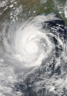
In the North Indian Ocean, Nisarga formed near southwest India and historically affected the cities of Alibag and Mumbai.
Nuri formed on the eastern coast of the Philippines, becoming the second storm of the typhoon season in the West Pacific but quickly weakened before landfall.
Near the end of the month, Dolly formed in the North Atlantic Ocean and became the third-earliest fourth named storm in the basin on record but dissipated before reaching any land.
In the eastern Pacific, a tropical cyclone outbreak resulted in the formation of Elida, Fausto, Genevieve, Hernan, and Iselle.
Although not directly making landfall, Hurricane Genevieve passed very close to Baja California Sur and caused minor damage.
Activity in the Western Pacific increased significantly with the formation of Jangmi, Mekkhala, a tropical depression that didn't affect land, and Higos in the South China Sea.
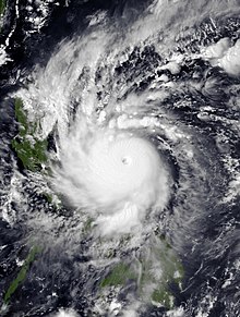
Iota eventually became one of the latest Category 4 hurricanes to be recorded in the North Atlantic basin, continuing a spree of damage in Central America following Eta.
In the Southern Hemisphere, Alicia and Tropical Depression 02 formed marking the beginning of the 2020–21 South–West Indian Ocean cyclone season.
Shortly after Gati, Nivar formed off the coast of Tamil Nadu and also began to quickly intensifiy to a Category 1 equivalent tropical cyclone before striking Karaikal.
Another depression formed in the West Pacific in the middle of the month and eventually strengthened into Tropical Storm Krovanh over the South China Sea.
Additionally, another system designated 03U formed near the Northern Territory and made landfall shortly afterwards, enhancing rainfall over the region.
The South-West Indian Ocean also featured one storm, Chalane, which brought minimal damage to Madagascar and impacted Mozambique.