Tropical Storm Hernan (2020)
Moving generally northward and paralleling the west coast of Mexico, Hernan was hindered by a high wind shear environment and only slightly strengthened.
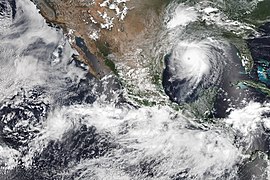
The cyclone achieved its peak intensity around 06:00 UTC on August 27 with maximum sustained winds of 70 km/h (45 mph) and a minimum barometric pressure of 1,001 mbar (29.6 inHg).
As Genevieve weakened west of the Baja California Peninsula, the monsoon trough, aided by a pulse of the Madden–Julian oscillation, developed three separate areas of low pressure.
However, beginning on August 24, the low and its associated shower and thunderstorm activity began to slowly become better organized and defined within marginally favorable conditions for tropical cyclogenesis.
After developing a cyclonic circulation and gale-force winds on August 26, the low became a tropical storm around 06:00 UTC that day, about 545 kilometers (340 miles) southwest of the municipality of Cabo Corrientes.
[1] However, the United States-based National Hurricane Center (NHC) operationally[c] did not recognize the system as having reached tropical storm strength until 21:00 UTC that day, at which time it was named Hernan.
Upon naming Hernan, the NHC noted that the storm was also located on the eastern side of a broad monsoon gyre, causing it to move in an eastward-to-northward fashion.
[3][4] Despite these unfavorable conditions, cloud tops south and west of Hernan's center cooled to between −83 and −86 °C (−117 and −123 °F) as its convection increased, allowing the cyclone to strengthen slightly.
[5] Hernan achieved peak intensity at 06:00 UTC on August 27 with maximum sustained winds of 70 km/h (45 mph) and a minimum barometric pressure of 1,001 mbar (29.6 inHg).
[13] Torrential rains and landslides affected coastal areas of Jalisco, including the resort city of Puerto Vallarta, where the Ameca River flooded, and forced the closure of the San Sebastián del Oeste-Mascota highway.
[16][17] Heavy rains left 30 communities in Jalisco without power; 18 people took shelter on their roofs during the flooding and had to be rescued by armed forces members.
[19] Severe flooding of homes and roads in Cihuatlán and La Huerta prompted the opening of four temporary shelters in the former municipality, which held 365 displaced residents.
[23] The federal legislature requested that the Comisión Nacional del Agua [es] (National Water Commission) carry out studies and take further preventive actions to address the lack of storm-resistant infrastructure in many coastal municipalities of Jalisco.
[25] Torrential rainfall from Hernan led to numerous rivers overflowing their banks across Colima, which resulted in severe and widespread flooding across coastal portions of the state.
Structures and roadways along the coast saw serious damage as roofs collapsed and flood waters swept away cars, toppled trees, knocked over power lines, and battered buildings.
[26] A parota tree blocked a road in the town of Tamala in the municipality of Ixtlahuacán, and residents across the area were advised to stay home by local government authorities during the storm's passage.
Secretary Ojeda Durán activated Plan DN-III-E to provide aid to individuals affected by Hernan in Guerrero and Oaxaca, and sent military personnel to the states to assist in recovery and cleanup efforts.

Tropical storm (39–73 mph, 63–118 km/h)
Category 1 (74–95 mph, 119–153 km/h)
Category 2 (96–110 mph, 154–177 km/h)
Category 3 (111–129 mph, 178–208 km/h)
Category 4 (130–156 mph, 209–251 km/h)
Category 5 (≥157 mph, ≥252 km/h)
Unknown