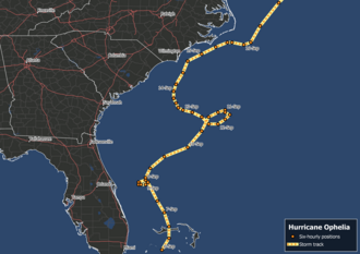
Hurricane Ophelia (2005)
Stuck in a region of meager steering currents, largely dominated by a lull between two ridges to the north and east, this system moved along a looping course with a general northward trajectory.
[3] Additionally, the El Niño–Southern Oscillation (ENSO) was in a neutral phase, lowering the likelihood of storms making landfall on the East Coast of the United States and leading to a concentration of impacts farther west.
[6] Forecasters at the National Hurricane Center (NHC)[nb 2] described the dual lows as a "complex scenario" and stated that possible tropical cyclogenesis would be slow to occur.
[6][9] Based on satellite data and synoptic observations, the NHC estimated that Tropical Depression Sixteen formed around 06:00 UTC[nb 3] on September 6 between Andros and Grand Bahama.
[11] Situated within a region of weak steering currents, the depression drifted generally north and later north-northwest, crossing Grand Bahama around 16:00 UTC.
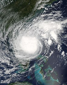
[15] The system became more organized on September 7 and intensified into Tropical Storm Ophelia approximately 115 mi (185 km) east-southeast of Cape Canaveral, Florida.
Following the formation of an eyewall and well-defined upper-level outflow,[18][19][20] Ophelia intensified into a hurricane around 21:00 UTC on September 8 with sustained winds reaching 75 mph (120 km/h).
[6][20] The hurricane's prolonged lack of movement resulted in the upwelling of cooler waters which in turn caused it to weaken back to a tropical storm early on September 9.
[25] However, Ophelia's structure once again improved late on September 10 with a 35 mi (55 km) wide eye developing;[26] this coincided with it regaining hurricane status for the third time.
[6][27] Gradual degradation of the hurricane's structure occurred as it looped back to the west-southwest, with meager convection unable to maintain vertical mixing.
[28] Sea surface temperatures beneath the system had plummeted to an average of 74.3 °F (23.5 °C) by this time,[29] and with insufficient heat content convection within the eyewall collapsed.
[32] As part of their annual Hurricane Field Program, the National Oceanic and Atmospheric Administration (NOAA) conducts research flights into tropical cyclones to study internal mechanics and improve forecasts.
[45] The multitude of recon flights during the developmental stages of Ophelia provided detailed data that supported the first in-depth study of the role of mesoscale convective systems in the genesis of tropical cyclones.
A collaborative effort between NOAA and Canada's Atmospheric Environment Service, two recon missions were flown into the storm to study structural changes during this transitory period.
The hurricane's erratic movement led to watches and warnings being issued for a much larger region than necessary across the East Coast of the United States, with some forecasts calling for landfalls that did not verify.
[59] Forecasts on September 10 indicated Ophelia would strike South Carolina and local emergency management officials held meetings to discuss preparations.
[60] Governor Mark Sanford requested the Federal Emergency Management Agency (FEMA) suspend transport of Katrina refugees to the receiving centers in Charleston and Colombia.
[68] Horry County officials revised evacuation procedures in light of the large loss of life from Katrina in the Gulf Coast, with emphasis placed on relocating poor, sick, and elderly persons.
[84] Linemen originally sent to the Gulf Coast were recalled to the state and 140 additional workers from South Carolina Electric & Gas Company were provided.
[91] The CHC initially forecast hurricane-force winds to impact parts of Nova Scotia, but later tempered expectations as Ophelia weakened on approach.
[93] Expected rainfall from the storm led to Nova Scotia's Department of Natural Resources ending a fire ban for western areas of the province on September 15.
[94] Nova Scotia Power, criticized for its poor response after Juan, placed hundreds of workers on standby and requested additional personnel from other provinces.
They highlighted the recent devastation wrought by Katrina in the United States and damaging events in Atlantic Canada over the past several years.
[38] On September 12, the body of a man was found in Palm Beach Shores near an empty boat; his death is presumed to be the result of rough seas produced by Ophelia.
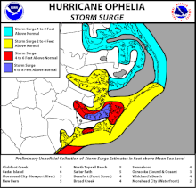
[107][112] Sustained winds at St. Simons reached 35 mph (56 km/h) while a minor storm surge of 1.87 ft (0.57 m) was observed at the Fort Pulaski National Monument.
[114] In South Carolina, persistent onshore flow beginning on September 7 caused significant erosion at Hunting Island State Park.
South Carolina Governor Sanford signed an executive order providing members of their state's National Guard, and personnel and equipment from their Emergency Management Department.
[160] Band Together, a nonprofit organization, held a disaster relief show for victims of Katrina and Ophelia on September 21; benefits went to the Food Bank of Central & Eastern North Carolina.
The influx of brackish water into the Emily and Richardson Preyer Buckridge Coastal Reserve negatively impacted the health of local Chamaecyparis thyoides (Atlantic white cedar) trees.
[169] Ecological biochemistry composition along the Neuse River estuary saw little disturbance; however, disruption to ferry services limited the sample frequency during data collection.

Tropical storm (39–73 mph, 63–118 km/h)
Category 1 (74–95 mph, 119–153 km/h)
Category 2 (96–110 mph, 154–177 km/h)
Category 3 (111–129 mph, 178–208 km/h)
Category 4 (130–156 mph, 209–251 km/h)
Category 5 (≥157 mph, ≥252 km/h)
Unknown