Hurricane Paine (1986)
With a high pressure system to its north, the depression moved generally westward at first, although an approaching upper-level trough influenced a more northerly track.
Late on September 30, a NOAA reconnaissance plane flew into the storm, one of two cyclones in the basin that warranted aircraft data, the other being Hurricane Newton.
[1] Hurricane Paine did not intensify further due to the presence of mid-level wind shear, as well as insufficient moisture in the air; nevertheless, it was located over an area of 82.9 °F (28.3 °C) water temperatures.
The outer eyewall moved across Cabo San Lucas, and the resultant land interaction was believed to have slightly weakened the inner core of the hurricane.
[2] After reaching its peak intensity, the hurricane turned north-northeastward, making landfall near San José, Sonora with winds of 90 mph (140 km/h).
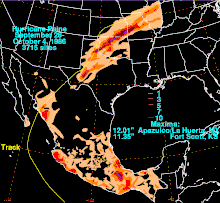
[3] As a tropical cyclone, Paine brought rainfall to most of Mexico, including heavier amounts along the coastline and interior northern Oaxaca.
[8] The remnants of Paine brought about the end of the extended period of rainfall, which overall had forced 55,000 people from their homes, including 1,200 in East Saint Louis, Illinois where a floodgate broke.

Tropical storm (39–73 mph, 63–118 km/h)
Category 1 (74–95 mph, 119–153 km/h)
Category 2 (96–110 mph, 154–177 km/h)
Category 3 (111–129 mph, 178–208 km/h)
Category 4 (130–156 mph, 209–251 km/h)
Category 5 (≥157 mph, ≥252 km/h)
Unknown