Hurricane Igor
As it passed west of Bermuda as a minimal hurricane, damage was primarily limited to trees and power lines, with roughly 27,500 residences losing electricity.
Hurricane Igor was first identified as a broad area of low pressure accompanying a tropical wave over western Africa in early September 2010.
At 06:00 UTC on September 8, the low was deemed sufficiently organized to be classified as a tropical depression while situated roughly 90 mi (140 km) southeast of Cabo Verde.
Attaining gale-force winds six hours later, the depression intensified into a tropical storm and was subsequently named Igor by the National Hurricane Center (NHC).
[2] Development of Igor quickly abated once it was named, as a nearby disturbance produced moderate wind shear over the storm, displacing convection from its center.
Embedded within a monsoon trough over the eastern Atlantic, the system maintained a slow westward track as it weakened to a tropical depression on September 9.
Intensification resumed the following day once shear lessened, while the dominant steering factor shifted to a mid-tropospheric ridge north of Igor; it would remain so throughout the remainder of the cyclone's existence.
During this time, satellite estimates indicated that the storm's winds increased from 75 to 150 mph (121 to 241 km/h) and its barometric pressure decreased by 52 mbar (hPa; 1.53 inHg).
[2] Near the end of this phase, forecasters at the NHC predicted that Igor would attain Category 5 status, the highest classification on the Saffir–Simpson scale.
[4] With a symmetrical 17 mi (27 km) wide eye, deep convection, and spiral banding,[5] Igor maintained Category 4 intensity for nearly five days.
[2] Passing roughly 345 mi (555 km) northeast of the Leeward Islands on September 17, Igor gradually weakened as it experienced increased wind shear and dry air intrusion.
Over the following several days, the storm curved toward the north and became exceedingly large,[2] with tropical storm-force winds covering an area about 865 mi (1,392 km) wide.
[6] Due to an overestimated bias in Igor's intensity, forecasts from the NHC showed that the storm would strike Bermuda as a major hurricane.
[14] Forming near Cabo Verde, Igor prompted the issuance of tropical storm watches for the southern islands on September 8.
[18] In nearby Haiti, still reeling from a devastating earthquake in January, officials warned residents of possible relocation from "tent cities" to safer areas.
[24] Officials in Bermuda stated that the biggest loss from Igor would be lessened tourism revenue following a mass exodus prior to the hurricane's arrival.
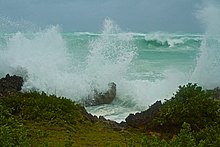
[2] Though Igor's closest approach to the contiguous United States only brought it within 600 mi (970 km) of land, its large circulation produced significant swells along the entire East Coast.
[29] On September 20, roughly one day prior to Igor's arrival in Atlantic Canada, the Canadian Hurricane Center (CHC) issued tropical storm watches and warnings for southern Newfoundland and the French territory of Saint Pierre and Miquelon.
[2] Although sustained hurricane-force winds were recorded across parts of the island, warnings were not issued due to stronger-than-expected re-intensification of the storm as it transitioned into an extratropical cyclone.
[30] The combination of a stationary front and significant moisture from Hurricane Igor resulted in torrential rainfall across parts of eastern Newfoundland, leading to widespread flooding.
[2][30][nb 2] In St. Lawrence, a confirmed 9.37 in (238 mm) of rain fell,[2] ranking Igor as the third-wettest tropical cyclone in Canadian history.
[36] A 100 ft (30 m) section of the Trans-Canada Highway in Terra Nova National Park was severely eroded, leaving a large ravine behind and disconnecting the main population of Newfoundland from the rest of the island.
[38] The small coastal community of South East Bight sustained some of the most significant wind damage, where entire fishing sheds were hurled into the air.
[42] Three ships and a fleet of helicopters were called in for the distribution of emergency aid, and the military set up temporary bridges while long-term plans for reconstruction were made.
[38] Operation Lama also enabled partial repairs of several buildings, and simultaneously, emergency personnel surveyed roughly 500 mi (800 km) of roads in Newfoundland.
[45] In late October, the Government of Newfoundland and Labrador allocated $275,000 in funds for 200 workers who lost their jobs after two fish processing plants were damaged in Marystown and Port Union.
[46] Following more than a year of discussions, the plant's parent company, Ocean Choice International, decided to permanently shut down operations on December 2, 2011.
[48] Over the course of the recovery phase, several complaints, including concerns lodged by church ministers, remarked that relief funds were not being distributed fast enough and the overall process was taking too long.
[51] In June 2011, a federal document detailing the actions made by province officials was released to be public and incited further outcry from residents affected by the storm.
[55] Because of the extensive damage the hurricane caused in Newfoundland, the name Igor was retired in the spring of 2011 by the World Meteorological Organization, and will never again be used for an Atlantic tropical cyclone.

Tropical storm (39–73 mph, 63–118 km/h)
Category 1 (74–95 mph, 119–153 km/h)
Category 2 (96–110 mph, 154–177 km/h)
Category 3 (111–129 mph, 178–208 km/h)
Category 4 (130–156 mph, 209–251 km/h)
Category 5 (≥157 mph, ≥252 km/h)
Unknown