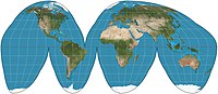
Interruption (map projection)
The reason for doing so is to improve distortion within the map by sacrificing proximity—that is, by separating places on the globe that ought to be adjacent.
Because the regions are smaller, they cover less of the globe, are closer to flat, and therefore accrue less inevitable distortion.
[2] Because pseudocylindric projections map parallels as straight lines, and meridians to have constant spacing, they are easy to interrupt.
Buckminster Fuller proposed his "dymaxion" map in 1943, using a modified icosahedral interruption scheme to divide the oceans up in a way that shows the continents in a nearly continuous mass as "one island".
[4] The most elaborate interruptions schemes include those of Athelstan Spilhaus along continental boundaries,[5] and JJ Wijk's myriahedral projections.