Interstate 75 in Kentucky
The major landscapes traversed by I-75 include the rolling hills and mountains of the Cumberland Plateau, the flat Bluegrass region, the urban core of Lexington, and the highly urbanized suburbs of Northern Kentucky; it also very briefly crosses through the Eastern Kentucky Coalfield at its southernmost stretch and passes near the Daniel Boone National Forest in London.
Due to the rapid growth and high traffic volume in the Lexington metropolitan area and Northern Kentucky, many widening projects and renovations have been undertaken on I-75 since then.
Skirting the foothills of the Cumberland Plateau, the Interstate briefly parallels Clear Fork and crosses it before reaching the welcome center.
[15][16] The Interstate turns a bit north and parallels a small stream for 9 miles (14 km) before reaching a direct interchange with US 25.
Approximately 10 miles (16 km) after this, the Interstate enters the rocky Pottsville Escarpment to reach Madison County and from here, descends into the flat Bluegrass region.
I-64/I-75 stays northwest passing some of Lexington's neighborhoods such as Radcliffe, Joyland, and Winburn before meeting KY 922 (Newtown Pike) for the Bluegrass Parkway and Blue Grass Airport.
Its next interchange roughly one mile (1.6 km) after that is with KY 1973 (Iron Works Pike), providing indirect access to US 25, before entering Scott County a short distance later and crossing a stream known as Cane Run.
[13][14][22] Exiting the Lexington urban area and meandering its way through farmland, I-75 makes a turn to the northeast, then the northwest as it crosses the north branch of the Elkhorn Creek approaching Georgetown.
[24] I-75 passes through lush greenery and farmland, then crosses a branch of the Eagle Creek to reach an interchange with KY 32 near Sadieville.
The Interstate passes by more lush farmland for another 5 miles (8.0 km) to Dry Ridge, where it meets KY 22/KY 467 (Broadway Street), which both serve the downtown area.
From here, it passes Florence and interchanges with KY 536 (Mount Zion Road) and rolls by the campus of Gateway Community and Technical College.
[28] Passing near the mall and the Florence Y'all Water Tower, I-71/I-75 makes a turn to the northeast and has an interchange with KY 18 (Burlington Pike).
While the program would take approximately 13 to 16 years, the length of I-75 was mostly complete to standards, running from the Ohio River at Covington to an unknown point north of Richmond in Madison County.
This resulted in a 70-mile (110 km) gap left to be filled in, as the other segment of I-75 in Laurel County, just north of Corbin, would continue on to the Tennessee state line, ultimately down south to Knoxville.
[31] On December 15, 1961, Bert Combs, Wilson W. Wyatt, and Henry Ward selected I-75 as one of three stretches to be in a ribbon-cutting ceremony, along with the KY 55 and US 127 interchanges along I-64.
[32]On December 19, several days later, the southernmost portion of the 21.5-mile (34.6 km) segment of I-75 at the KY 22 interchange in Dry Ridge was officially dedicated to the public as well.
Although US 25 goes through several communities, the government announced that I-75 would bypass these places to the west, avoiding their traffic lights and low speed limits and saving drivers several minutes of time.
I-75 between Clays Ferry and Richmond had already been built, and the bypass at Frankfort helped shorten the driving time between Lexington and Louisville anywhere from 15 to 25 minutes.
[43] By December 30, 1967, a three-mile (4.8 km) portion at Mount Vernon was opened and connected to US 25 at both ends, providing a bypass around the city and relieving a bottleneck for many travelers.
As the problem had been persisting for several years, the process to renovate the interchange was divided into five phases: planning, preliminary engineering and environmental evaluation, design, right of way and utility coordination, and construction.
Around November 1990, the state received $21 million in funds to widen a 7.7-mile (12.4 km) section of I-75 in Scott County to three lanes from a weigh station to the Eagle Creek bridges.
The northern portion of the project, located at milepost 40.7 to 48, involves the segment running from south of KY 909 to London, a distance of about 7.29 miles (11.73 km).
[53] Currently, the section of I-64/I-75 in Lexington is also undergoing widening; this segment was a length of 2.3 miles (3.7 km), extending from milepost 112.9 to 115.2 and at a cost of $48 million.
The project is estimated to widen the roadway to eight lanes to improve traffic flow as the interchanges in Lexington experience heavy congestion.
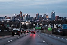
[56][57][58] It is a steep descent into the valley of the Ohio River between Kyles Lane and the Brent Spence Bridge leading into Downtown Cincinnati.
[61] At the Cut-in-the-Hill, the northbound road takes a sharp left turn into a steep grade down to the Ohio River—about 370 feet (110 m) in four miles (6.4 km).
[62] Accidents are usually attributed to a combination of speeding, curvy lanes, poor weather, longer stopping times for trucks traveling downhill, and traffic congestion.
[62] In 1986, a tractor-trailer lost control, leading to an accident that caused a Northern Kentucky University student to burn to death in his car.
[61][66] Also as part of the reconstruction, ramps were added at Pike Street to give complete access, while an interchange with Jefferson and Euclid avenues was obliterated.
To help reduce the number of accidents, a flashing "Steep Grade" sign was installed and a Kentucky State Police trooper was assigned to patrol just the Cut-in-the-Hill.