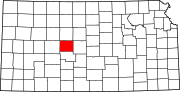
La Crosse, Kansas
[3] La Crosse proclaims itself the "Barbed Wire capital of the world.
[7] On May 25, 2012, an EF-1 tornado caused about four blocks of significant damage, and two businesses were destroyed.
[8] La Crosse lies in the Smoky Hills region of the Great Plains, approximately 12 miles (19 km) south of the Smoky Hill River and 5 miles (8.0 km) north of Walnut Creek, a tributary of the Arkansas River.
[9][11] According to the United States Census Bureau, the city has a total area of 1.05 square miles (2.72 km2), all land.
[13] The 2020 United States census counted 1,266 people, 547 households, and 318 families in La Crosse.
34.2% of households consisted of individuals and 18.3% had someone living alone who was 65 years of age or older.
36.6% of all households were made up of individuals, and 18.5% had someone living alone who was 65 years of age or older.
33.5% of all households were made up of individuals, and 18.3% had someone living alone who was 65 years of age or older.
La Crosse is a city of the third class, according to state statute, with a commission-manager form of government.
[27] The city commission consists of the mayor and two commissioners, and it meets on the second and fourth Wednesday of each month.
[28] The community is served by La Crosse USD 395 public school district, and operates three schools in the city:[29][30] U.S. Route 183 runs north-south through La Crosse, intersecting Kansas Highway 4 (K-4) which runs east-west along the northern edge of the city.
[9] Rush County Airport is located northeast of the city on the north side of K-4.
[31] A line of the Kansas and Oklahoma Railroad runs southeast-northwest through La Crosse.
[10] One newspaper, The Rush County News, is published weekly in La Crosse.