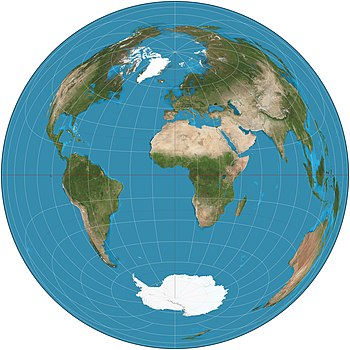
Lambert azimuthal equal-area projection
The Lambert azimuthal equal-area projection is a particular mapping from a sphere to a disk.
For example, the National Atlas of the US uses a Lambert azimuthal equal-area projection to display information in the online Map Maker application,[3] and the European Environment Agency recommends its usage for European mapping for statistical analysis and display.
[4] It is also used in scientific disciplines such as geology for plotting the orientations of lines in three-dimensional space.
This plotting is aided by a special kind of graph paper called a Schmidt net.
Consider the projection centered at S = (0, 0, −1) on the unit sphere, which is the set of points (x, y, z) in three-dimensional space R3 such that x2 + y2 + z2 = 1.
[7] As defined in the preceding section, the Lambert azimuthal projection of the unit sphere is undefined at (0, 0, 1).
It sends the rest of the sphere to the open disk of radius 2 centered at the origin (0, 0) in the plane.
The projection is a diffeomorphism (a bijection that is infinitely differentiable in both directions) between the sphere (minus (0, 0, 1)) and the open disk of radius 2.
It is an area-preserving (equal-area) map, which can be seen by computing the area element of the sphere when parametrized by the inverse of the projection.
On the other hand, the projection does not preserve angular relationships among curves on the sphere.
This fact, that flat pictures cannot perfectly represent regions of spheres, is the fundamental problem of cartography.
As a consequence, regions on the sphere may be projected to the plane with greatly distorted shapes.
The set of all such lines is itself a space, called the real projective plane in mathematics.
Every line through the origin intersects the unit sphere in exactly two points, one of which is on the lower hemisphere z ≤ 0.
Hence the directions in three-dimensional space correspond (almost perfectly) to points on the lower hemisphere.
The hemisphere can then be plotted as a disk of radius √2 using the Lambert azimuthal projection.
Thus the Lambert azimuthal projection lets us plot directions as points in a disk.
This is useful for statistical analysis of directional data,[6] including random rigid rotation.
[8] Not only lines but also planes through the origin can be plotted with the Lambert azimuthal projection.
Researchers in structural geology use the Lambert azimuthal projection to plot crystallographic axes and faces, lineation and foliation in rocks, slickensides in faults, and other linear and planar features.
be a "time" parameter (equal to the height, or vertical thickness, of the shell in the animation).
Each frame in the animation corresponds to a parametric plot of the deformed grid at a fixed value of the shell height
This generalized mapping includes the Lambert projection as a special case when
Application: this mapping can assist in explaining the meaning of a Lambert projection by showing it to "peel open" the sphere at a pole, morphing it to a disk without changing area enclosed by grid cells.