Laptev Sea
The sea shores were inhabited for thousands of years by indigenous tribes of Yukaghirs and then Evens and Evenks, which were engaged in fishing, hunting and reindeer husbandry.
[1] There are several dozens of islands with the total area of 3,784 km2 (1,461 sq mi), mostly in the western part of the sea and in the river deltas.
As centuries went by, gradually, most of the area limiting the sea to the south became filled with the alluvial deposits of modern rivers.
[9] Usually, ice formation starts in September on the north and October on the south, though it has progressively begun later because of human-driven climate change.
[10] In 2020 Siberia experienced record-breaking heat and formation did not begin until late October, marking the latest start ever recorded.
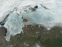
Ice is drifting north to this coastal band,[3] and several polynyas are formed by the warm south winds around there.
In summer, the surface layer in the ice-free zones warms up by the sun up to 8–10 °С in the bays and 2–3 °С in the open sea, and remains close to 0 °С under ice.
Owing to the ice melting season, about 90% of the annual runoff occurs between June and September with 35–40% in August alone, whereas January contributes only 5%.
[3] Sea currents form a cyclone consisting of the southward stream near Severnaya Zemlya which reaches the continental coast and flows along it from west to east.
[1][3] Owing to the weak winds and shallow waters, the sea is relatively calm with the waves typically within 1 meter (3 ft 3 in).
[17] By 1712, Yakov Permyakov and Merkury Vagin explored the eastern part of the Laptev Sea and discovered Bolshoy Lyakhovsky Island.
In 1770, the merchant Ivan Lyakhov revisited the islands and then asked the government for permission to commercially develop their ivory resources.
While exploring the area in the 1770s, Lyakhov described several other islands, including Kotelny, which he named so after a large kettle (Russian: котёл – kotel) left there by previous visitors.
During the 1739–1742 Great Northern Expedition, Russian Arctic explorer and Vice Admiral Dmitry Laptev described the sea coastline from the mouth of the Lena River, along the Buor-Khaya and Yana gulfs, to the strait that bears his name, Dmitry Laptev Strait.
As part of the same expedition, Dmitry's cousin Khariton Laptev's led a party that surveyed the coast of the Taimyr Peninsula starting from the mouth of the Khatanga River.
[23][24] Detailed mapping of the coast of the Laptev Sea and New Siberian Islands was performed by Pyotr Anjou, who in 1821–1823 traveled some 14,000 km (8,700 mi) over the region on sledges and small boats, searching for the Sannikov Land and demonstrating that large-scale coastal observations can be performed without ships.
On the ship Zarya, Toll carried out geological and geographical surveys in the area on behalf of the Russian Imperial Academy of Sciences.
[6] The coastal flora mainly consists of mosses and lichens and a few flowering plants including Arctic poppy (Papaver radicatum), Saxifraga, Draba and small populations of polar (Salix polaris) and creeping (Salicaceae) willows.
[35] Permanent mammal species include ringed seal (Phoca hispida), bearded seal (Erignathus barbatus), harp seal (Pagophilus groenlandicus), walrus (Odobenus rosmarus), collared lemming (Dicrostonyx torquatus), Arctic fox (Alopex lagopus),[36] reindeer (Rangifer tarandus) wolf (Canis lupus), ermine (Mustela erminea), Arctic hare (Lepus timidus) and polar bear (Ursus maritimus), whereas beluga whales (Delphinapterus leucas) visit the region seasonally.
[37] The walrus of the Laptev Sea is sometimes distinguished as a separate subspecies Odobenus rosmarus laptevi, though this attribution is questioned.
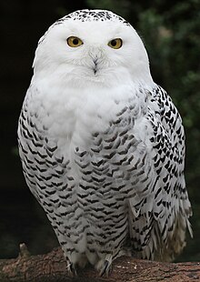
Some belong to permanent (tundra) species, such as snow bunting (Plectrophenax nivalis), purple sandpiper (Calidris maritima), snowy owl (Bubo scandiacus) and brent goose and other make large colonies on the islands and sea shores.
[1][3] Data are available for the Khatanga Bay and deltas of the Lena and Yana rivers from 1981 to 1991 which translate into about 3,000 tonnes of fish annually.
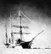
The route was difficult even for icebreakers – so Lenin (pictured) and her convoy of five ships were trapped in ice in the Laptev Sea around September 1937.
In order to explore them in the extreme Arctic conditions, a Gulag penal labor camp was established in Nordvik.
Drilling revealed only small, shallow oil pockets in connection with salt structures with little commercial significance.
Although the original prospects for oil at Nordvik did not materialize, experience was gained in the exploration for hydrocarbons within the continuous permafrost zones.
This experience proved invaluable in the later exploration and exploitation of the massive oil and gas fields of Western Siberia.
The penal colony was closed and its traces erased in the mid-1940s right before Americans arrived in Nordvik as allies of the Soviet Union.
The program aims at long-term, systematic and thorough measurements of clouds, radiation, aerosols, surface energy fluxes and chemistry in the Arctic.
[50] The water pollution is relatively low and mostly originates from the numerous plants and mines standing on the Lena, Yana and Anabar rivers.