Geography of Vietnam
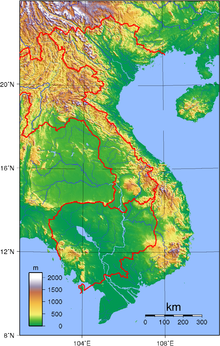
Vietnam is located on the eastern margin of the Indochinese peninsula and occupies about 331,211.6 square kilometres (127,881.5 sq mi), of which about 25% was under cultivation in 1987.
The frontier with Cambodia, defined at the time of French annexation of the western part of the Mekong Delta in 1867, remained essentially unchanged, according to Hanoi, until some unresolved border issues were finally settled in the 1982–85 period.
However, in February 1979, following the Sino-Vietnamese War, Hanoi complained that from 1957 onward China had provoked numerous border incidents as part of its anti-Vietnam policy and expansionist designs in Southeast Asia.
Among the territorial infringements cited was the Chinese occupation in January 1974 of the Paracel Islands, claimed by both countries in a dispute left unresolved in the 1980s.
Vietnam is a country of subtropical and tropical lowlands, hills, and densely forested highlands, with level land covering less than 20% of the area.
Modeled on that of China's, this ancient system has sustained a highly concentrated population and has made double-cropping wet-rice cultivation possible throughout about half the region.
The Dãy Trường Sơn (Annamite Range) originates in the Tibetan and Yunnan regions of southwest China and forms Vietnam's border with Laos.
The northern section is narrow and very rugged; the country's highest peak, Fan Si Pan, rises to 3,142 meters in the extreme northwest.
For centuries these topographical features not only rendered north–south communication difficult, but also formed an effective natural barrier for the containment of the people living in the Mekong basin.
Within the southern portion of Vietnam is a plateau known as the Central Highlands (Tây Nguyên), approximately 51,800 square kilometers of rugged mountain peaks, extensive forests, and rich soil.
On the landward side, the Dãy Trường Sơn rises precipitously above the coast, its spurs jutting into the sea at several places.
[4] The Mekong Delta, covering about 40,000 square kilometers, is a low-level plain not more than three meters above sea level at any point and criss-crossed by a maze of canals and rivers.
A tributary entering the river at Phnom Penh drains the Tonlé Sap, a shallow freshwater lake that acts as a natural reservoir to stabilize the flow of water through the lower Mekong.
[5]: 35 Natural resources: phosphates, coal, manganese, rare earth elements, bauxite, offshore oil and gas deposits, timber, hydropower Land use: Irrigated land: 45,850 km2 (2005) Total renewable water resources: 864.1 km3 (2011) Freshwater withdrawal (domestic/industrial/agricultural): Natural hazards: occasional typhoons (May to January) with extensive flooding, especially in the Mekong Delta.
Environment – current issues: Logging and slash-and-burn agricultural practices contribute to deforestation and soil degradation; water pollution and overfishing threaten marine life populations; groundwater contamination limits potable water supply; growing urbanization and human migration are rapidly degrading environment in Hanoi and Hồ Chí Minh City Environment – international agreements: party to: Biodiversity, Climate Change, Climate Change-Kyoto Protocol, Desertification, Endangered Species, Environmental Modification, Hazardous Wastes, Law of the Sea, Ozone Layer Protection, Ship Pollution (MARPOL 73/78), Wetlands Vietnam is among the most affected countries by global climate change.
[12] A large number of studies show that Vietnam is experiencing climate change and will be severely negatively affected in coming decades.
These negative effects include sea level rise, salinity intrusion and other hydrological problems like floods, river mouth evolution and sedimentation.
Natural hazards such as cold waves, storm surges will increase in frequency, with negative effects on the country's development, infrastructure and economy.