Major explorations after the Age of Discovery
Eighteenth-century British explorer James Cook mapped much of Polynesia and traveled as far north as Alaska and as far south as the Antarctic Circle.
British explorer James Cook, who had been the first to map the North Atlantic island of Newfoundland, spent a dozen years in the Pacific Ocean.
Cook made three voyages to the Pacific, including the first European contact with the eastern coastline of Australia and the Hawaiian Islands (although oral tradition seems to point towards a far earlier Spanish expedition having achieved the latter), as well as the first recorded circumnavigation of New Zealand.
[2] Cook's second expedition included the artist William Hodges, who produced notable landscape paintings of Tahiti, Easter Island, and other locations.
Cook gathered accurate longitude measurements during his first voyage with the help of astronomer Charles Green and by using the newly published Nautical Almanac tables, via the lunar distance method — measuring the angular distance from the Moon to either the Sun during daytime or one of eight bright stars during night-time to determine the time at the Royal Observatory, Greenwich, and comparing that to his local time determined via the altitude of the Sun, Moon, or stars.
Between 1799 and 1804, Baron Alexander von Humboldt a German naturalist and explorer, traveled extensively in Spanish America, under the protection of king Charles IV of Spain.
His expedition may be regarded as having laid the foundation of the sciences of physical geography and meteorology, exploring and describing for the first time in a manner generally considered to be a modern scientific point of view.
[5] As a consequence of his explorations, von Humboldt described many geographical features and species of life that were hitherto unknown to Europeans and his quantitative work on botanical geography was foundational to the field of biogeography.
By his delineation of "isothermal lines", in 1817 he devised the means of comparing the climatic conditions of various countries, and to the detection of the more complicated law governing atmospheric disturbances in higher latitudes; he discovered the decrease in intensity of Earth's magnetic field from the poles to the equator.
His attentive study of the volcanoes of the New World, showed that they fell naturally into linear groups, presumably corresponding with vast subterranean fissures, and he demonstrated the igneous origin of rocks.
The details and findings of Humboldt's journey were published in a set of 30 volumes over 21 years, his Personal Narrative of Travels to the Equatorial Regions of the New Continent.
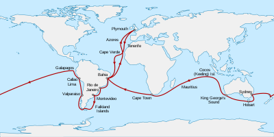
[citation needed] In December 1831 a British expedition departed under captain Robert FitzRoy, on board HMS Beagle, with the main purpose of making a hydrographic survey of the coasts of South America using calibrated chronometers and astronomical observations, producing charts for naval war or commerce.
The longitude of Rio de Janeiro was to be found and also a geological survey made of a circular coral atoll in the Pacific Ocean.
By the end of the expedition he had already made his name as a geologist and fossil collector, and the publication of his journal, known as The Voyage of the Beagle, gave him wide renown as a writer.
He ably collected and made detailed observations of plants and animals, with results that shook his belief that species were fixed, and provided the basis for ideas which came to him when back in England, leading to his theory of evolution by natural selection.
[12] His observations of the marked differences across a narrow strait in the archipelago led to his proposing the zoogeographical boundary now known as the Wallace line, that divides Indonesia into two distinct parts: one with animals closely related to those of Australia, and one in which the species are largely of Asian origin.
In 1878, he warned about the dangers of deforestation and soil erosion in tropical climates, like the extensive clearing of rainforest for coffee cultivation in Ceylon (Sri Lanka) and India.
Nyasa had been first reached by the confidential slave of António da Silva Porto, a Portuguese trader established at Bié in Angola, who crossed Africa during 1853–1856 from Benguella to the mouth of the Rovuma.
[15] These travellers not only added considerably to geographical knowledge, but obtained invaluable information concerning the people, languages and natural history of the countries in which they sojourned.
But the first western discoverer of the pygmies of Central Africa was Paul Du Chaillu, who found them in the Ogowe district of the west coast in 1865, five years before Schweinfurth's first meeting with them.
Portuguese Serpa Pinto was the fourth explorer to cross Africa from west to east and the first to lay down a reasonably accurate route between Bié (in present-day Angola) and Lealui.
From 1884 to 1886, Hermenegildo Capelo and Roberto Ivens crossed Southern Africa between Angola and Mozambique to map the unknown territory of the Portuguese colonies.
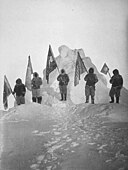
The Norwegian Roald Amundsen finally reached the Pole in December 1911, following a dramatic race with the Englishman Robert Falcon Scott.
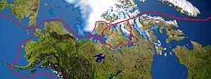
Interest kindled in 1564 after Jacques Cartier's discovery of the mouth of the Saint Lawrence River, Martin Frobisher had formed a resolution to undertake the challenge of forging a trade route from England westward to India.
Though he was unable to pass through the icy Arctic waters, he reported to his sponsors that the passage they sought is "a matter nothing doubtfull [sic],"[citation needed] and secured support for two additional expeditions, reaching as far as Hudson Bay.
Though England's efforts were interrupted in 1587 because of Anglo-Spanish War, Davis's favorable reports on the region and its people would inspire explorers in the coming century.
[22] The obsession of the undiscovered continent culminated in the brain of Alexander Dalrymple, a hydrographer who was nominated by the Royal Society to command the Transit of Venus expedition to Tahiti in 1769.
It is certain that on 28 January 1820 (New Style), the expedition led by Fabian von Bellingshausen and Mikhail Petrovich Lazarev on two ships reached a point within 20 miles (40 km) of the Antarctic mainland and saw ice-fields there.
Only slightly more than a year later, the first landing on the Antarctic mainland was arguably by the American Captain John Davis, a sealer, who claimed to have set foot there on 7 February 1821, though this is not accepted by all historians.
In 1914 Ernest Shackleton's Imperial Trans-Antarctic Expedition set out with the goal of crossing Antarctica via the South Pole, but his ship, the Endurance, was frozen in pack-ice and sank 11 months later.