March 2017 North American blizzard
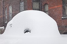
The March 2017 North American blizzard also known as Winter Storm Stella was a major late-season blizzard that affected the Northeastern United States, New England and Canada, dumping up to 3 feet (36 in; 91 cm) of snow in the hardest hit areas, mainly New York, Vermont, New Hampshire and southern Quebec.
Forming out of an extratropical cyclone near the Northwest, the storm system dived into the northern portions of the United States, dropping light to moderate snow across the Great Lakes, Upper Midwest on March 11–12 before reaching the Ohio Valley the next day.
It later coalesced into a powerful nor'easter off the East Coast, producing a swath of heavy snowfall across a large portion of the Northeast.
[3][4][5] Ahead of the storm, residents prepared in advance for the major nor'easter, with blizzard warnings issued for several states, including New York, Pennsylvania, New Jersey, Connecticut, Rhode Island, and Massachusetts.
It dropped a swath of moderate snow accumulation as it moved across the northern tier of the country, with as much as 13 inches (33 cm) reported.
The storm was also responsible for ending a record streak without snowfall in Chicago, Illinois, where no snow had occurred since December 25, 2016.
The system moved swiftly across the Upper Midwest throughout the day of March 12, dropping a swath of accumulating snow of 3–6 inches (7.6–15.2 cm) as frontogenesis took place.
[8] On March 13 at 15:00 UTC, the Weather Prediction Center began issuing storm summaries while the system was located west-northwest of St. Louis, Missouri.
[9] Throughout the day, a weak secondary area of low pressure formed in the Gulf of Mexico and drifted northeastwards, while not expected to fuse with the other low to its north, it helped inject moisture from the ocean over the state of Florida, which gradually began to merge with the outermost fringes of the northerly system that had now moved into the Ohio Valley.
The storm began to rapidly deepen as it moved parallel to the East Coast of the United States, with the central pressure dropping to 986 millibars (29.1 inHg) by 15:00 UTC on March 14 while it was just off the Maryland coastline.
[15] The system continued to weaken as it moved slowly through upper New England, the system continued to weaken, consequently, the Weather Prediction Center terminated storm summaries on the winter storm as nearly most of the moderate to heavy snow had stopped in the region and switched to rain.
[16] The reduction in snowfall totals was due to a shift in the storm's track to the west more towards the New Jersey coastline, which resulted in more mixed precipitation rather than snow.
Meteorologists at the National Weather Service were aware of the changing conditions that led to lesser snow accumulations along the coast the night prior to the expected event.
They sought to avoid sending mixed and/or incorrect messages about a dangerous storm by maintaining a steady forecast.
[22] On March 11, the National Weather Service issued blizzard watches for parts of the Northeast, including New York City.
[23] Late on March 12, officials issued a hazardous travel advisory in advance of the storm, which was predicted to bring up to 18 inches (46 cm) of snow to parts of the state, including Staten Island.
[24] The following day on March 13, New York City mayor Bill de Blasio urged the residents of the region to avoid traveling at any point due to the dangerous conditions and also allowing for sanitation crews to respond faster.
[25] The New York City Department of Sanitation said that they had nearly 700 salt spreaders across the boroughs of the state, and 1,600 plows would be dispatched to clear the roadways.
Pennsylvania Governor Tom Wolf signed a proclamation of disaster that day and stated that speeds would be restricted on most major freeways.
[37] The United States Postal Service closed post offices and cancelled mail delivery for several locations in Pennsylvania on March 14.
A state of emergency was declared in Maryland by Governor Larry Hogan, urging people to prepare for the storm and stay off the roads.
[45] In Boston, the Massachusetts Emergency Management Agency said that they had mechanics working on loads of equipment to get ready for plowing the roads.
[49] On March 13, Connecticut Governor Dannel Malloy issued a statewide travel ban, ordering all non-essential first and second shift employees to remain home.
Bridgeport Mayor Joe Ganim declared a snow emergency late on March 12 while Hartford officials warned city residents of a parking ban beginning at 8 p.m. EDT the following day.
The Metropolitan Transportation Authority deployed extra staff and specialized equipment, while Peter Pan Bus Lines canceled services from upstate New York to Washington D.C. Eversource Energy and The United Illuminating Company contacted city and town leaders for organization prior to the storm and assistance in its wake.
Because the system tracked farther inland than expected on the US East Coast, snow accumulations forecast constantly increased on March 12–13 in Ontario and Quebec.
[122][123] It rapidly intensified in the afternoon over portions of Southern Quebec and the Eastern Townships before becoming a powerful blizzard over Montreal and its South Shore, as heavy snow bands came from the South-East and did a wrap-around effect just on the South Shore of Montreal, where the snow fell at a rate of more than 7.5 cm/hr (3 in/hr) for more than 6 hours between 6PM and midnight.
[124] Winds from the Northeast increased in the Saint Lawrence River between Montreal and Quebec City in the evening, producing the blizzard.
[126] At least two more (both elderly males) were found dead in Montreal in parked cars over the following days, presumably killed by heart attacks while attempting to clear them out.
[127] The storm started affected New Brunswick in the afternoon on March 14, with the other Atlantic Canadian provinces being hit in the early evening.