Meteorological history of Hurricane Andrew
However, wind shear soon impacted the storm, causing significant increases in barometric pressure and nearly destroying its low-level circulation by August 20.
However, the storm then rapidly, but briefly restrengthened into a Category 5 hurricane, and was at that intensity when it struck Elliott Key and just south of Homestead, Florida on August 24.
Early on August 26, Andrew weakened slightly to a low-end Category 3 hurricane before making landfall near Morgan City, Louisiana.
An area of convection developed along the wave axis to the south of the Cape Verde islands, and on August 15 meteorologists began classifying the system with the Dvorak technique.
Based on a Dvorak T-number of 2.0, it is estimated Tropical Depression Three developed late on August 16 about 1,630 miles (2,620 km) east-southeast of Barbados.
[1] By early on August 18, the storm maintained concentrated convection near the center with spiral bands to its west as the winds increased to 50 miles per hour (80 km/h).
[3] Shortly thereafter the thunderstorms decreased markedly during the diurnal minimum,[4] and as the storm turned to the northwest increased southwesterly wind shear from an upper-level low prevented Andrew from maintaining deep convection.
Simultaneously, a strong high pressure cell developed over the southeastern United States, which built eastward and caused Andrew to turn to the west.
[6] An eye formed, and Andrew attained hurricane status early on August 22, while located about 650 miles (1,050 km) east-southeast of Nassau, Bahamas.
[8] As it crossed over the warm waters of the Gulf Stream in the Straits of Florida, the hurricane rapidly re-intensified, as the eye decreased in size and its eyewall convection deepened.
[1] At 08:40 UTC on August 24, Andrew struck Elliott Key as a Category 5 hurricane, with winds of 165 miles per hour (266 km/h) and a central pressure of 926 mbar.
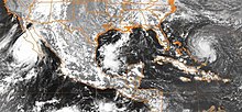
[1] In the Gulf of Mexico, the eye remained well-defined as the hurricane turned to the west-northwest, a change due to the weakening of the ridge to its north.
The project concluded that Category 5 conditions on land occurred only in a small region of southern Dade (now Miami-Dade) County, specifically close to the coast in Cutler Ridge.
[1] The highest recorded surface gust, within Andrew's northern eyewall, occurred at the home of a resident about a mile from the shoreline in Perrine, Florida.