Hurricane Hattie
Hattie then turned westward west of Jamaica and strengthened into a Category 5 hurricane, with maximum sustained winds of 165 mph (270 km/h).
Hattie first affected the southwestern Caribbean, where it produced hurricane-force winds and caused one death on San Andres Island.
For a few days toward the end of October 1961, a low-pressure area persisted in the western Caribbean Sea, north of the Panama Canal Zone.
[2] On October 25, an upper-level anticyclone moved over the low; the next day, a trough over the western Gulf of Mexico provided favorable outflow for the disturbance.
The two observations confirmed the presence of a closed wind circulation, centered about 70 miles (110 km) southeast of San Andres, or 155 mi (249 km) east of the Nicaraguan coast; as a result, the Miami Weather Bureau began issuing advisories on the newly formed Tropical Storm Hattie.
A station on the island recorded a pressure of 991 mbar (29.3 inHg) and sustained winds of 80 mph (130 km/h), which indicated that Hattie had reached hurricane status.
[2] Early on October 29, a trough extending from Nicaragua to Florida was expected to allow Hattie to continue northward, based on climatology for similar hurricanes.
[2] Around that time, a strengthening ridge to the north turned the hurricane northwestward, which spared the Greater Antilles but increased the threat to Central America.
Late on October 29, the center of the hurricane passed about 90 miles (140 km) southwest of Grand Cayman, at which time the interaction between Hattie and the ridge to its north produced squally winds of around 30 mph (48 km/h) across Florida.
Late on October 30, Hattie attained peak winds of 165 mph (266 km/h), concomitantly with a minimum central pressure of 914 mbar (27.0 inHg), about 190 mi (310 km) east of the border of Mexico and British Honduras.
After moving through several small islands offshore, the hurricane made landfall a short distance south of Belize City on October 31, with an eyewall of about 25 miles (40 km) in diameter.
During landfall, a ship anchored between Belize City and Stann Creek registered a minimum central pressure of 924 mbar (27.3 inHg).
[6] Upon initiating advisories on Hattie, the Miami Weather Bureau noted the potential for heavy rainfall and flash flooding in the southwestern Caribbean.
[2] Officials at the Miami Weather Bureau warned of the potential for high tides, strong winds, and torrential rainfall.
[9] Despite predictions for heavy rainfall in the southwestern Caribbean, the hurricane's movement was more northerly than expected, resulting in less precipitation along the Central American coast than anticipated.
Weather Bureau issued a small craft warning for the west and east Florida coastlines, as well as northward to Brunswick, Georgia.
[11] Later, Hattie impacted various countries in Central America with flash floods, causing 11 deaths in Guatemala and one fatality in Honduras.
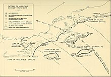
[3] The hurricane left significant crop damage across the region, including $2 million in citrus fruits and similar losses to timber, cocoa, and bananas.
[9] A manager of United Press International described Belize City as "nothing but a huge pile of matchsticks,"[9] and many roads were either flooded for days or covered with mud.
Due to the high death toll, officials ordered mass cremations to stop additional disease from spreading.
[9] Many residents throughout British Honduras donated supplies to the storm victims, such that an airlines manager described it as "taxing ... manpower and facilities."
[16] By November 5, Belize City's post office reopened on a limited basis, and all business initially remained closed.
Prime Minister George Cadle Price successfully appealed for assistance from the British government, which ultimately provided £20 million in loans.
[27] In the days after the storm, the government announced plans to relocate the capital of British Honduras farther inland on higher ground.

Tropical storm (39–73 mph, 63–118 km/h)
Category 1 (74–95 mph, 119–153 km/h)
Category 2 (96–110 mph, 154–177 km/h)
Category 3 (111–129 mph, 178–208 km/h)
Category 4 (130–156 mph, 209–251 km/h)
Category 5 (≥157 mph, ≥252 km/h)
Unknown