Hurricane Camille
Located in a favorable environment for strengthening, the storm quickly intensified into a Category 2 hurricane before striking the western part of Cuba on August 15.
Emerging into the Gulf of Mexico, Camille underwent another period of rapid intensification and became a Category 5 hurricane the next day as it moved northward towards Louisiana and Mississippi.
It tracked quickly westward along the 15th parallel north;[4] several days later, a tropical disturbance became clearly identifiable on satellite imagery on August 9.
As the storm approached the western coast of Cuba, it began rapid deepening, reaching hurricane status and less than 12 hours later attained winds of 110 mph (180 km/h).
Camille was a small hurricane as it crossed western Cuba, and its winds decreased slightly to 105 mph (169 km/h) over land before it emerged into the Gulf of Mexico.
[5] Before they left the storm, the crew recorded a pressure of 919 mbar (hPa; 27.14 inHg) and estimated surface winds at 155 mph (249 km/h), while Camille was located about 100 miles (160 km) southeast of the Mississippi River Delta.
[6] There were no subsequent Hurricane Hunter flights, but surface observations recorded later suggested that Camille quickly re-strengthened and regained Category 5 intensity.
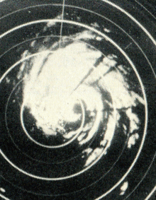
[9] Maximum sustained wind speeds near the coastline were estimated to have been about 175 mph (282 km/h), with a minimum central pressure of 900 mbar (hPa; 26.58 inHg) as analyzed by surface data.
[5] Subsequently, Camille began to interact with a frontal storm, causing it to gradually transition into an extratropical cyclone as it entrained cooler air.
[5][6] Shortly after Camille formed, the National Hurricane Center advised residents on the Isle of Pines and in western Cuba to prepare for gale-force winds, heavy rains, and rising tides.
[6] The threat of the storm prompted officials to evacuate thousands along the western coast of Cuba and on the Isle of Pines; on the island, 10,000 cattle and 6,000 turkeys were moved to safer areas.
During the afternoon of August 16, the weather bureau ordered that a hurricane watch should be placed in force for the coastline from Biloxi to St Marks, Florida.
[12] Making landfall in Waveland, Mississippi, as a Category 5 hurricane,[7] Camille caused damage and destruction across much of the Gulf Coast of the United States.
[citation needed] In addition, Camille forced the Mississippi River to flow backwards for a river-distance of 125 miles (from its mouth to a point north of New Orleans).
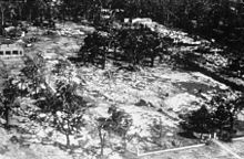
The worst-hit areas were Clermont Harbor, Lakeshore, Waveland, Bay St. Louis, Pass Christian, Long Beach, and the beachfront of Gulfport, Mississippi City, and Biloxi.
In actuality, there was no party; 23 people are known to have stayed in the apartments during the hurricane, eight of whom died despite taking all precautions they knew in order to secure the building.
[5] Places farther east across the western Florida panhandle saw lesser rains, as 4.16 inches (106 mm) was measured at Pensacola Naval Air Station.
[27] Camille caused moderate rainfall in Tennessee and Kentucky of between 3 and 5 inches (130 mm),[28] helping to relieve a drought in the area, yet in West Virginia, there was flash flooding which destroyed 36 houses and 12 trailers, a total of three quarters of a million dollars in damage.
A widespread area of western and central Virginia received over 8 inches (200 mm) of rain from Camille's remains, leading to significant flooding across the state.
There, rainfall was so heavy that reports were received of birds drowning in trees, cows floating down the Hatt Creek and of survivors having to cup hands around their mouth and nose in order to breathe through the deluge.
Most gauges were washed away; however, it was reported that an empty 55 US gallons (210 L) drum that was not even in the center of the heaviest rainfall had 31 inches (79 cm) of water in it after Camille passed.
[36][30][37][38] In the days after the storm struck Cuba, the government deployed medical teams to affected regions to provide typhoid vaccine shots.
[39] President Richard Nixon ordered 1450 regular troops and 800 United States Army Engineers into the area to bring tons of food, vehicles, and aircraft.
When many of the evacuees returned by Tuesday, Governor John Bell Williams declared martial law, blocking highways into the area and leading to a 6 p.m. to 6 a.m. curfew.
The governor also opened Camp Shelby, dormitories within the University of Southern Mississippi, and the Robert E. Lee Hotel to serve as shelters for those who lost homes.
During the evening of September 8, President Nixon visited the Biloxi-Gulfport Regional Airport and gave a speech to elevate the spirits of local residents struggling with the storm's aftermath.
In 1973, hurricane hunters and their associated reconnaissance aircraft relocated to Keesler Air Force Base when their previous headquarters at Ramey, Puerto Rico, closed.
NOAA Weather Radio was expanded to coastal locations during the 1970s in the wake of Camille based upon recommendations made by the Department of Commerce in September 1969.
"[39] Due to the high death toll and major destruction in much of the Southern United States, the name Camille was retired after the 1969 season, and will never again be used for an Atlantic basin tropical cyclone.
John Hope's daughter Camille was involved in an advanced science and math program in high school and had carried out a required independent research project.

Tropical storm (39–73 mph, 63–118 km/h)
Category 1 (74–95 mph, 119–153 km/h)
Category 2 (96–110 mph, 154–177 km/h)
Category 3 (111–129 mph, 178–208 km/h)
Category 4 (130–156 mph, 209–251 km/h)
Category 5 (≥157 mph, ≥252 km/h)
Unknown