Micronesian navigation
These voyagers used wayfinding techniques such as the navigation by the stars, and observations of birds, ocean swells, and wind patterns, and relied on a large body of knowledge from oral tradition.
[4] The re-creations of Polynesian voyaging in the late 20th century used traditional stellar navigational methods that had remained in everyday use in the Caroline Islands.
He earned the title of master navigator (palu) by the age of eighteen in 1950; which involved the sacred initiation ritual known as Pwo.
As he neared middle age, he grew concerned that the practice of navigation in Satawal would disappear as his people became acculturated to Western values.
In the hope that the navigational tradition would be preserved for future generations, Mau shared his knowledge with the Polynesian Voyaging Society (PVS).
[19] In 1969, Hipour accompanied David Henry Lewis on his ketch Isbjorn from Puluwat in Chuuk to Saipan in the Northern Mariana Islands, and back, using traditional navigation techniques; a distance of approximately 1,000 km (621.37 mi) each way.
[20][21] In April 1970, Repunglug and Repunglap, half-brothers, navigated from Satawal to Saipan in a traditional Carolinian outrigger canoe, which was approximately 26 feet (7.92 m) long, and equipped with a canvas sail.
They include Sautan on Elato; Orupi, a Satawal man residing on Lamotrek; Ikegun, Epaimai, Repunglug, Repunglap, and Mau Piailug from Satawal; Ikuliman, Ikefie, Manipi, Rapwi, Faipiy, Faluta, Filewa and Hipour, all from Puluwat; Yaitiluk from Pulap, and Amanto from Tamatam.
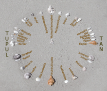
[21][4] The Carolinian navigation system, used by Mau Piailug, relies on navigational clues using the Sun and stars, winds and clouds, seas and swells, observing the flight path of birds, and the patterns of bioluminescence that indicated the direction in which islands were located,[22][23] which skills were acquired through rote learning passed down through teachings in the oral tradition.
Stars, as opposed to planets, hold fixed celestial positions year-round, changing only their rising time with the seasons.
Any star that passes through the zenith (overhead) moves along the celestial equator, the basis of the equatorial coordinate system.
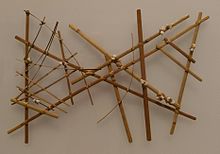
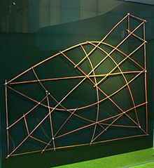
[27] The use of stick charts ended after World War II when new electronic technologies made navigation more accessible and travel among islands by canoe lessened.