Mount St. Helens
Mount St. Helens (known as Lawetlat'la to the local Cowlitz people, and Loowit or Louwala-Clough to the Klickitat) is an active stratovolcano located in Skamania County, Washington,[1] in the Pacific Northwest region of the United States.
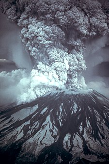
[5] A massive debris avalanche, triggered by a magnitude 5.1 earthquake, caused a lateral eruption[6] that reduced the elevation of the mountain's summit from 9,677 to 8,363 ft (2,950 to 2,549 m), leaving a 1 mile (1.6 km) wide horseshoe-shaped crater.
It stood out prominently from surrounding hills because of the symmetry and extensive snow and ice cover of the pre-1980 summit cone, earning it the nickname, by some, "Fuji-san of America".
[13]: 201 Its ice cover just prior to the 1980 eruption included eleven named glaciers: Wishbone, Loowit, Leschi, Forsyth, Nelson, Ape, Shoestring, Swift, Dryer, Toutle, and Talus.
[15]: 297 That north–south highway skirts the low-lying cities of Castle Rock, Longview and Kelso along the Cowlitz River, and passes through the Vancouver, Washington–Portland, Oregon metropolitan area less than 50 miles (80 km) to the southwest.
Mount St. Helens is part of the Cascades Volcanic Province, an arc-shaped band extending from southwestern British Columbia to Northern California, roughly parallel to the Pacific coastline.
As the oceanic slab sinks deeper into the Earth's interior beneath the continental plate, high temperatures and pressures allow water molecules locked in the minerals of solid rock to escape.
[13]: 214 St. Helens started its growth in the Pleistocene 37,600 years ago, during the Ape Canyon stage, with dacite and andesite eruptions of hot pumice and ash.
Another 5,000 years of dormancy followed, only to be upset by the beginning of the Swift Creek eruptive period, typified by pyroclastic flows, dome growth and blanketing of the countryside with tephra.
[13]: 215 [31] This eruptive period lasted until about 1600 BC and left 18 inches (46 cm) deep deposits of material 50 miles (80 km) distant in what is now Mount Rainier National Park.
Large lava flows of andesite and basalt covered parts of the mountain, including one around the year 100 BC that traveled all the way into the Lewis and Kalama river valleys.
[34] Roughly 700 years of dormancy were broken in about 1480, when large amounts of pale gray dacite pumice and ash started to erupt, beginning the Kalama period.
(The 1831 eruption is likely what tinted the sun bluish-green in Southampton County, Virginia on the afternoon of August 13—which Nat Turner interpreted as a final signal to launch the United States' largest slave rebellion.
[57] Larger species saw greater mortality rates,[57] with each of the area's large mammals — mountain goats, elk, deer, black bear and cougars — completely decimated.
In the story, the chief of all the gods and his two sons, Pahto (also called Klickitat) and Wy'east, traveled down the Columbia River from the Far North in search for a suitable area to settle.
They find the area above its tree line to be of exceptional spiritual significance, and the mountain (which they call "Lawetlat'la", roughly translated as "the smoker") features prominently in their creation story, and in some of their songs and rituals.
[66] In recognition of its cultural significance, over 12,000 acres (4,900 ha) of the mountain (roughly bounded by the Loowit Trail) have been listed on the National Register of Historic Places.
[67] Royal Navy Commander George Vancouver and the officers of HMS Discovery made the Europeans' first recorded sighting of Mount St. Helens on 19 May 1792, while surveying the northern Pacific Ocean coast.
Vancouver named the mountain for British diplomat Alleyne Fitzherbert, 1st Baron St Helens on 20 October 1792,[65][68] as it came into view when the Discovery passed into the mouth of the Columbia River.
[13]: 217 Alarmed by the "dry snow", the Nespelem tribe of northeastern Washington supposedly danced and prayed rather than collecting food and suffered during that winter from starvation.
[13]: 217 In late 1805 and early 1806, members of the Lewis and Clark Expedition spotted Mount St. Helens from the Columbia River but did not report either an ongoing eruption or recent evidence of one.
[69] They did however report the presence of quicksand and clogged channel conditions at the mouth of the Sandy River near Portland, suggesting an eruption by Mount Hood sometime in the previous decades.
[70] The first authenticated non-Indigenous eyewitness report of a volcanic eruption was made in March 1835 by Meredith Gairdner, while working for the Hudson's Bay Company stationed at Fort Vancouver.
James Dwight Dana of Yale University, while sailing with the United States Exploring Expedition, saw the quiescent peak from off the mouth of the Columbia River in 1841.
[12] In October 1843, future California governor Peter H. Burnett recounted a very likely apocryphal story of an Indigenous man who badly burned his foot and leg in lava or hot ash while hunting for deer.
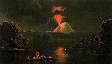
[13]: 224 British lieutenant Henry J. Warre sketched the eruption in 1845, and two years later Canadian painter Paul Kane created watercolors of the gently smoking mountain.
Eighty-three-year-old Harry R. Truman, who ran the Spirit Lake Lodge and had lived near the mountain since 1929, gained much media attention when he decided not to evacuate before the impending eruption, despite repeated pleas by local authorities.
[87] On May 14, 2023, a mudslide and debris flow given the moniker, South Coldwater Slide by the U.S. Forest Service, destroyed the 85-foot (26 m) Spirit Lake Outlet Bridge on Washington State Route 504 and cut off access to the Johnston Ridge Observatory.
The northern segment of the trail from the South Fork Toutle River on the west to Windy Pass on the east is a restricted zone where camping, biking, pets, fires, and off-trail excursions are all prohibited.
[97][98] On April 14, 2008, John Slemp, a snowmobiler from Damascus, Oregon, fell 1,500 feet into the crater after a snow cornice gave way beneath him on a trip to the volcano with his son.