Great Basin Desert
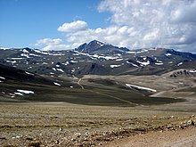
The biological communities of the Great Basin Desert vary according to altitude: from low salty dry lakes, up through rolling sagebrush valleys, to pinyon-juniper forests.
The significant variation between valleys and peaks has created a variety of habitat niches which has in turn led to many small, isolated populations of genetically unique plant and animal species throughout the region.
According to Grayson,[6] more than 600 species of vertebrates live in the floristic Great Basin, which has a similar areal footprint to the ecoregion.
The desert's high elevation and location between mountain ranges influences regional climate: the desert formed by the rain shadow of the Sierra Nevada that blocks moisture from the Pacific Ocean, while the Rocky Mountains create a barrier effect that restricts moisture from the Gulf of Mexico.
[1] This article describes the general ecology of the region, including the high-elevation areas, and does not rely on minor differences in the definitions of the ecoregion or desert.
The climate of the Great Basin desert is characterized by extremes: hot, dry summers and cold, snowy winters; frigid alpine ridges and warm, windy valleys; days over 90 °F (32 °C) followed by nights near 40 °F (4 °C).
Weather coming in from the Pacific Ocean quickly loses its moisture as rain and snow as it is forced up and over the steep mountains.
[18] Moisture that manages to reach the ecoregion tends to precipitate as rain and snow in higher elevations, primarily over the region's long, parallel mountains.
Climate, elevation, soil type, and many anthropogenic variables greatly influence the diversity and distribution of shrubland, grassland, and woodland communities in the desert.
Heading from the valley bottoms to the mountain peaks one will encounter constantly changing combinations of plant and animal species making up some 200 distinct biological communities.
On the shores of the playas, shadscale is the dominant plant, but is kept company by iodine bush,[7] saltgrass,[7] spiny hopsage, winterfat, four-winged saltbrush, and green rabbitbrush.
[21] The soil salinity and lack of moisture in this zone is not very conducive to most agriculture; however, livestock grazing and grain farming have historically contributed to a decline in the already scattered vegetation.
[21] Isolated from one mountain range to the next, montane communities in the region have long individual histories, each one affected differently by chance factors of migration over vast expanses of desert.
Treeline is generally found above 10,000 feet (3,000 m) in the Great Basin desert, moving downslope with higher latitudes.
Water-loving plants like willow, narrowleaf cottonwood, choke cherry, wild rose, and aspen are found along these wet areas.
Vegetation is mostly absent, although scattered salt-tolerant plants, such as pickleweed, iodinebush, black greasewood, and inland saltgrass occur.
The basins in Nevada, in contrast to those in Utah, are more constricted in area and are more influenced by nearby mountain ranges with extensive carbonate rock exposures, which provide water by percolation through the limestone substrate to surface as valley springs.
Playas occur in the lowest elevation of the Lahontan Basin, and represent the terminus or sink of rivers running east of the Sierra Nevada.
Black greasewood or four-winged saltbush may grow around the perimeter in the transition to the salt shrub community, where they often stabilize areas of low sand dunes.
Although there is a direct connection to the south to the Mojave Desert, winters are cold enough in this ecoregion to discourage the northward dispersal of Mojavean species into the Lahontan Basin.
In addition to shadscale, other salt-tolerant shrubs, such as Shockley's desert-thorn and Bailey greasewood, cover the lower basin slopes.
These areas are rock controlled and their soils lack the fine lacustrine sediments that are found in lower parts of the Lahontan Basin.
Pinyon grows with juniper on the Stillwater Range and on Fairview Peak in the southeast portion of the Lahontan Basin, but it is otherwise absent from this ecoregion.
Low sagebrush is common in extensive areas of shallow, stony soil, as are cool season grasses, such as bluebunch wheatgrass, Idaho fescue, and Sandberg bluegrass.
However, as in the warmer Lahontan Basin to the west, lightning fires are common and a post-fire monoculture of cheatgrass tends to replace the native grasses and shrubs.
The combination of summer moisture and a limestone or dolomite substrate affects regional vegetation, particularly in terms of species dominance and elevational distribution.
Alluvial fans spilling from the surrounding mountain ranges fill the valleys, often leaving little intervening flat ground.
Pinyon-juniper grows only sparsely through the shrub layer due to combined effects of past fire, logging, and local climate factors, including lack of summer rain and the pattern of winter cold air inversions.
The Toiyabe Range (west of Big Smoky Valley) is high enough to have an alpine zone, but lacks a suitable substrate to retain snowmelt moisture.
Similar to basins further north, shadscale and associated arid land shrubs cover broad rolling valleys, hills, and alluvial fans.