Noachian
[3] Weathering of surface rocks produced a diversity of clay minerals (phyllosilicates) that formed under chemical conditions conducive to microbial life.
Reconciling the geologic evidence of river valleys and lakes with computer climate models of Noachian Mars has been a major challenge.
[16] Models that posit a thick carbon dioxide atmosphere and consequent greenhouse effect have difficulty reproducing the higher mean temperatures necessary for abundant liquid water.
[21] In particular, much of the river- and lake-forming activity appears to have occurred over a relatively short interval at the end of the Noachian and extending into the early Hesperian.
[26] Noachian-aged units cover 45% of the Martian surface;[27] they occur mainly in the southern highlands of the planet, but are also present over large areas in the north, such as in Tempe and Xanthe Terrae, Acheron Fossae, and around the Isidis basin (Libya Montes).
[37] A system is bound above and below by strata with distinctly different characteristics (on Earth, usually index fossils) that indicate dramatic (often abrupt) changes in the dominant fauna or environmental conditions.
[35][39] Across many areas of the planet, the top of the Noachian System is overlain by more sparsely cratered, ridged plains materials interpreted to be vast flood basalts similar in makeup to the lunar maria.
The system was conceived originally to encompass rock units dating back to the formation of the crust 4500 million years ago.
[25] However, work by Herbert Frey and colleagues at NASA's Goddard Spaceflight Center using Mars Orbital Laser Altimeter (MOLA) data indicates that the southern highlands of Mars contain numerous buried impact basins (called quasi-circular depressions, or QCDs) that are older than the visible Noachian-aged surfaces and that pre-date the Hellas impact.
The series are based on referents or locations on the planet where surface units indicate a distinctive geological episode, recognizable in time by cratering age and stratigraphic position.
The Earth-based scheme of formal stratigraphic nomenclature has been successfully applied to Mars for several decades now but has numerous flaws.
Obtaining radiometric ages on samples from identified surface units is clearly necessary for a more complete understanding of Martian history and chronology.
[3] The lunar cratering record suggests that the rate of impacts in the Inner Solar System 4000 million years ago was 500 times higher than today.
[44] During the Noachian, about one 100-km diameter crater formed on Mars every million years,[3] with the rate of smaller impacts exponentially higher.
[a] Such high impact rates would have fractured the crust to depths of several kilometers[46] and left thick ejecta deposits across the planet's surface.
Large impacts would have profoundly affected the climate by releasing huge quantities of hot ejecta that heated the atmosphere and surface to high temperatures.
[48] By analogy with the Moon, frequent impacts produced a zone of fractured bedrock and breccias in the upper crust called the megaregolith.
[51] Computer models of heat and fluid transport in the ancient Martian crust suggest that the lifetime of an impact-generated hydrothermal system could be hundreds of thousands to millions of years after impact.
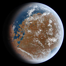
[59] Water draining from the southern highlands during the Noachian would be expected to pool in the northern hemisphere, forming an ocean (Oceanus Borealis[60]).
Unfortunately, the existence and nature of a Noachian ocean remains uncertain because subsequent geologic activity has erased much of the geomorphic evidence.
[65] In 2010, researchers used the global distribution of deltas and valley networks to argue for the existence of a Noachian shoreline in the northern hemisphere.
[3] Extensive volcanism also occurred in the cratered highlands outside of the Tharsis region, but little geomorphologic evidence remains because surfaces have been intensely reworked by impact.
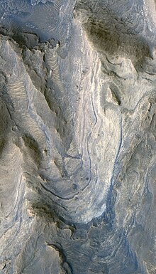
[3] Spectral evidence from orbit indicates that highland rocks are primarily basaltic in composition, consisting of the minerals pyroxene, plagioclase feldspar, and olivine.
[68] The rocks are mainly degraded basalts with a variety of textures indicating severe fracturing and brecciation from impact and alteration by hydrothermal fluids.
[3] In many areas of the planet (most notably Nili Fossae and Mawrth Vallis), subsequent erosion or impacts have exposed older Pre-Noachian and Lower Noachian units that are rich in phyllosilicates.
In 2006, researchers using the OMEGA instrument on the Mars Express spacecraft proposed a new Martian era called the Phyllocian, corresponding to the Pre-Noachian/Early Noachian in which surface water and aqueous weathering was common.