Gall–Peters projection
[2] The Gall–Peters projection achieved notoriety in the late 20th century as the centerpiece of a controversy about the political implications of map design.
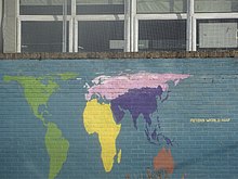
Peters's original description of his projection contained a geometric error that, taken literally, implies standard parallels of 46°02′ N/S.
However the text accompanying the description made it clear that he had intended the standard parallels to be 45° N/S, making his projection identical to Gall's orthographic.
[5]: 155 These arguments swayed many socially concerned groups to adopt the Gall–Peters projection, including the National Council of Churches[8] and the magazine New Internationalist.
He also inaccurately claimed that it possessed "absolute angle conformality", had "no extreme distortions of form", and was "totally distance-factual".
Since Mercator produced his global map over four hundred years ago for the age of Europeans world domination, cartographers have clung to it despite its having been long outdated by events.
They have sought to render it topical by cosmetic corrections.… The cartographic profession is, by its retention of old precepts based on the Eurocentric global concept, incapable of developing this egalitarian world map which alone can demonstrate the parity of all peoples of the earth.
[12]As Peters's promotions gained popularity, the cartographic community reacted with hostility to his criticisms, as well as to the inaccuracy and lack of novelty of his claims.
[13] They called attention to the long list of cartographers who, over the preceding century, had formally expressed frustration with publishers' overuse of the Mercator and advocated for alternatives.
In 1989 and 1990, after some internal debate, seven North American geographic organizations adopted a resolution rejecting all rectangular world maps, a category that includes both the Mercator and the Gall–Peters projections,[20][21] though the North American Cartographic Information Society notably declined to endorse it.
While he likely devised the projection independently, his unscholarly conduct and refusal to engage the cartographic community undoubtedly contributed to the polarization and impasse.
[3] In the ensuing decades, J. Brian Harley credited the Peters phenomenon with demonstrating the social implications of map projections.