Pfrimm Viaduct
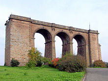
The remains of its northern stone arch bridge are located on the northeastern edge of the village at about 193 m above sea level (NHN).
About 240 metres south-southeast of the centre of the northern part of the bridge at a height of about 200 m[3] near the south bank of the Pfrimm are stone pier remains of the southern abutment.
The Pfrimm Viaduct was built as a 260-metre-long and 30-metre-high[2] stone arch and truss bridge with a superstructure of lattice and steel girder design between the years 1872 and 1874.
On 20 March 1945, Shortly before the end of the Second World War the bridge was blown up by withdrawing Wehrmacht troops.
Since the construction of the B 47 north of the viaduct, when the adjoining railway embankment (in the upper photograph the formerly covered stones are still visible during related work) was removed, the northern bridge remains have stood isolated in the open.