Roosevelt Boulevard (Philadelphia)
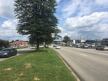
The road begins at Interstate 76 (Schuylkill Expressway) in Fairmount Park, running as a freeway also known as the Roosevelt Boulevard Extension or the Roosevelt Expressway through North Philadelphia, then transitioning into a twelve-lane boulevard that forms the spine of Northeast Philadelphia to its end at the city line.
Portions are concurrent with US 13 (between Hunting Park Avenue and Robbins Street) and Pennsylvania Route 63 (between Red Lion and Woodhaven Roads).
It crosses the Schuylkill River via the Twin Bridges and runs eastward through the neighborhoods of East Falls and Hunting Park.
[4] The Roosevelt Boulevard begins at an intersection with Hunting Park Avenue, continuing northeast as a part of US 13.
[4] The road continues east through Hunting Park and Feltonville, where it curves and resumes running in a northeasterly direction.
The boulevard continues past Pennypack Park and Northeast Philadelphia Airport, passing through two notoriously dangerous intersections[2] with Grant Avenue and Red Lion Road.
The road was designated U.S. 1 in 1926, and was extended through Philadelphia to neighboring Bucks County in the post-World War II years.
[11][12] In 2000, by act of the state legislature, the Boulevard was designated the "Police Officer Daniel Faulkner Memorial Highway" in memory of Daniel Faulkner, a Philadelphia police officer whom Mumia Abu-Jamal was convicted of having slain in the line of duty in 1981.
According to a 2001 report by State Farm Insurance, the second- and third-worst intersections in the country are both found on the Boulevard, at Red Lion Road and Grant Avenue, respectively, only a mile apart from each other.
[17] On June 1, 2020, speed cameras were activated along Roosevelt Boulevard, with a 60-day warning period before fines are issued.