Selenography
Historically, the principal concern of selenographists was the mapping and naming of the lunar terrane identifying maria, craters, mountain ranges, and other various features.
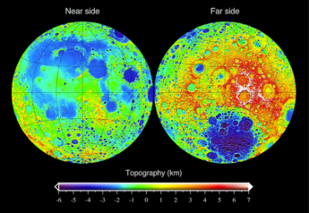
This task was largely finished when high resolution images of the near and far sides of the Moon were obtained by orbiting spacecraft during the early space era.
Nevertheless, some regions of the Moon remain poorly imaged (especially near the poles) and the exact locations of many features (like crater depths) are uncertain by several kilometers.
In the early 18th century, the librations of the Moon were measured, which revealed that more than half of the lunar surface was visible to observers on Earth.
The Moon has been measured by the methods of laser altimetry and stereo image analysis, including data obtained during several missions.
The most visible topographical feature is the giant far-side South Pole-Aitken basin, which possesses the lowest elevations of the Moon.
[4][obsolete source] The oldest known illustration of the Moon was found in a passage grave in Knowth, County Meath, Ireland.
William Gilbert made a drawing of the Moon in which he denominated a dozen surface features in the late 16th century; it was published posthumously in De Mondo Nostro Sublunari Philosophia Nova.
Denominations of the surface features of the Moon, based on telescopic observation, were made by Michael van Langren in 1645.
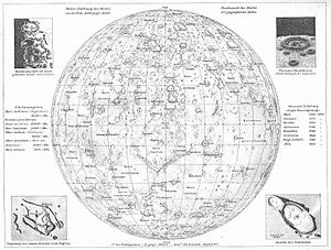
Minor craters were denominated in honor of astronomers, mathematicians, and other famous scholars.In 1647, Johannes Hevelius produced the rival work Selenographia, which was the first lunar atlas.
This work of Hevelius influenced his contemporary European astronomers, and the Selenographia was the standard reference on selenography for over a century.
Giambattista Riccioli, SJ, a Catholic priest and scholar who lived in northern Italy authored the present scheme of Latin lunar nomenclature.
The lunar illustrations in the Almagestum novum were drawn by a fellow Jesuit educator named Francesco Grimaldi, SJ.
Riccioli authored lunar toponyms derived from the names of various conditions, including climactic ones, whose causes were historically attributed to the Moon.
Craters in Octants I, II, and III were primarily denominated based on names from ancient Greece, such as Plato, Atlas, and Archimedes.
Toward the middle in Octants IV, V, and VI craters were denominated based on names from the ancient Roman Empire, such as Julius Caesar, Tacitus, and Taruntius.
Toward the southern half of the lunar cartograph (map) craters were denominated in honor of scholars, writers, and philosophers of medieval Europe and Arabic regions.
[citation needed] Many craters around the Mare Nectaris were denominated in honor of Catholic saints pursuant to the nomenclature of Van Langren.
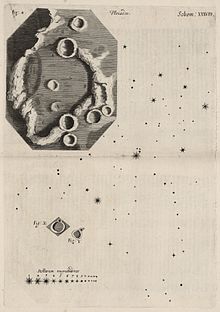
The most notable among these contributors was Johann H. Schröter, who published a very detailed cartograph (map) of the Moon in 1791 titled the Selenotopografisches Fragmenten.
The commission for denominating these features formally adopted the convention of using capital Roman letters to identify craters and valleys.
When suitable maps of the far side of the Moon became available by 1966, Ewen Whitaker denominated satellite features based on the angle of their location relative to the major crater with which they were associated.