South Turkmenistan Complex Archaeological Expedition
[4] In 1952, Boris Kuftin, established the basic Chalcolithics to Late Bronze Age sequence based on the excavations carried out at Namazga-Tepe (termed Namazga (NMG) I-VI).
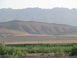
[3] Namazgtepe ('tepe' means "hill") is 100–120 kilometers from Ashgabat in Turkmenistan at the border with Iran, southeast of the Caspian Sea.
[7] The VII Brigade, carried out by Kuftin, was of the Namazgadepe explorations, which revealed six phases, sequentially deposited, and referred to as Namazga I to VI.
[1] In the Margiana archaeological expeditions undertaken during the second phase, work was continued at the Auchindepe and Takirbaidepe, which revealed 100 Bronze Age sites and the settlement of Gomur I.
The survey covered Jeitun Culture as a whole, and particular credit is given to the Turkmen archaeologist, O. K. Berdiev who died in an accident at a young age; his 10 years of explorations have been published under the title “The Most Ancient Agriculturalists of Southern Turkmenistan.” Neolithic pediment sites of Jeitun Culture extended from Bami in the west to the Meana Chacha district in the east.
[1] The IX Brigade, led by Okladnikov, worked in the Greater Balkan region of Turkmenistan, and in the plateau of Krasnovodsk.
[8] The explorations in the foothills of the Kopetdag revealed well developed irrigation systems with water control arrangements which resulted in prosperous, well settled large regional centres.
In the process of development over these centuries, the transition observed was from Chalcolithic period to Early Bronze Age with urban characteristics in the settlements.
From the highest point of this tepe, a trench was dug to a depth of 30 metres (98 ft) and the section was logged, which revealed layers of the Bronze Age, of neolithic and Eneolithic periods.
Early Bronze period fort walls with decorated towers and a huge entrance had encircled this settlement, though when found, they were in ruins.
[6][9] Discoveries by Soviet archeologists dated the finds at this place, in a chronological order, to the later half of the third millennium BC.
[11] The most notable findings in the burial ground of the elite, located in the outskirts of Altyndepe, were "a disk-like stone 'weight', a miniature column, more than 1500 beads, a steatite plate with an image of cross and half-moon, a moulded clay wolf, as well as a golden head of a bull with a turquoise sickle inlaid in the forehead".
The further findings were, However, the settlement gradually disappeared (it was deserted around 1600 BC) as a result of climatic changes; people migrated to the Mugrab region, another area of South Uzbekistan (Sapali), and Northern Afghanistan (Dashli).
[6] Geoksyur Oasis, located in the foothills of the Kopetdag, to the east of Altyndepe, is in the center of a cluster of tepes in the desert region on the northern Iranian border.
[6] According to the Greek-Russian archaeologist, Sarianidi, who explored the tepes, Gonurtepe was the "capital or the imperial city of a complex Bronze Age state, one that stretched at least a thousand square miles and encompassing hundreds of satellite settlements".
The main findings of the excavations are that the site was "an agricultural and herding community who grew grain, raised sheep, built sophisticated irrigation and sewage systems, and produced ceramics in the many kilns that dot the landscape."