Tropical Storm Fay (2008)
The sixth named storm of the 2008 Atlantic hurricane season, Fay formed from a vigorous tropical wave on August 15 over the Dominican Republic.
It passed just south of the Cape Verde Islands, and tracked generally westward with a subtropical ridge centered to its north over the Azores.
[5] With generally favorable conditions for development, the system began slowly organizing,[6] to the extent that on August 10, the National Hurricane Center (NHC) remarked for its potential to become a tropical depression in a few days.
[7] By August 11, however, the thunderstorm activity became disorganized and limited,[8] though the next day convection reformed by the time it was located about 650 mi (1,050 km) east of the Lesser Antilles.
[10] After the hurricane hunters' flight, the system became disorganized as environmental conditions became less favorable,[11] and by late on August 13 the convection was limited and well-removed from the low center.
[12] The next day, thunderstorm activity increased and organized,[13] though another hurricane hunters flight confirmed the system did not develop into a tropical cyclone.
[14] After passing over the northern Lesser Antilles, the system moved over the Virgin Islands and Puerto Rico, maintaining an area of deep convection.
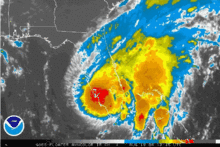
A reconnaissance flight measured wind gusts of 56 miles per hour (90 km/h) and was designated as Tropical Storm Fay late on August 15 as the cyclone moved ashore along eastern Dominican Republic.
[20] By early on August 17, a hurricane hunters flight reported a better organized circulation center, and satellite images displayed well-established outflow within a large convection envelope.
[21] After passing near or over southwestern Granma Province in Cuba, upper-level wind shear increased slightly, and the convection diminished near the center.
[23] Fay made four Florida landfalls, first at Key West in the late afternoon of August 18, then early the following morning at Cape Romano south of Naples as a 65 mph (105 km/h) tropical storm.
[26] Fay regained some strength, however, after leaving land at Melbourne and heading northward over the warm Atlantic Ocean waters, only to be deflected westward as it encountered a high pressure ridge.
Fay then emerged into the northeastern Gulf of Mexico and made its fourth landfall on the morning of August 23 near Carrabelle in the Florida Panhandle.
Fay narrowly missed making yet another landfall, the center staying barely onshore while passing Panama City and St. Andrews Bay.
[29][30][31][32] Additional tropical storm watches and warnings were issued in Jamaica, the Cayman Islands, Florida, Georgia, Alabama, Mississippi, and Louisiana.
[39] Fay's unexpected strengthening over land prompted a hurricane watch to briefly be issued for Northeastern Florida and Southeastern Georgia on August 19.
The system developed into a tropical storm while producing heavy rains on the island, prompting a major flash flood threat.
During seven days in Florida, August 18–24, 2008, eleven people died and thousands of homes plus roads were damaged, from 60 mph (97 km/h) winds and rain waters up to 5 feet (1.5 m) deep,[53] with flooded rivers or tornadoes, as Fay traveled through the entire state.
Returning from Mississippi towards Tennessee, Fay continued to dump heavy rains around Pensacola, Tallahassee, and Panama City even during August 25.
[60] A 28-year-old kite surfer was critically injured in Fort Lauderdale when winds associated with a Tropical Storm Fay feeder band slammed him face-first into the ground and then dragged him across the streets until he hit a building, which was filmed by a WFOR camera crew.
[59] Tropical Storm Fay resulted in the drowning of one person swimming off Neptune Beach and another swimmer in Duval County.

Tropical storm (39–73 mph, 63–118 km/h)
Category 1 (74–95 mph, 119–153 km/h)
Category 2 (96–110 mph, 154–177 km/h)
Category 3 (111–129 mph, 178–208 km/h)
Category 4 (130–156 mph, 209–251 km/h)
Category 5 (≥157 mph, ≥252 km/h)
Unknown