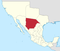
Chihuahua (state)
On the slope of the Sierra Madre Occidental mountains (around the regions of Casas Grandes, Cuauhtémoc and Parral), there are vast prairies of short yellow grass, the source of the bulk of the state's agricultural production.
[12] Between AD 300 and 1300 in the northern part of the state along the wide, fertile valley on the San Miguel River the Casas Grandes (Big Houses) culture developed into an advanced civilization.
The conquest of the territory lasted nearly one century and encountered fierce resistance from the Conchos tribe, but the desire of the Spanish Crown to transform the region into a bustling mining center led to a strong strategy to control the area.
In 1562, Francisco de Ibarra headed a personal expedition in search of the mythical cities of Cíbola and Quivira; he traveled through the present-day state of Chihuahua.
In April 1598, Juan de Oñate found a short route from Santa Bárbara to New Mexico which came to be called El Paso del Norte (The Northern Pass).
When Guerrero's liberal administration was overthrown in December, Gaspar de Ochoa aligned with Anastasio Bustamante, and in February 1830, organized an opposition group that arrested the new governor, F. Elorriaga, along with other prominent Yorkinos.
Although unable to resist the popular demand for the expulsion of the Spaniards, he soon quarreled with the legislature, which declared itself firmly for Guerrero, and announcing his support of Bustamante's revolution, he suspended, in March 1830, eight members of that body, the vice-governor, and several other officials, and expelled them from the state.
The course thus outlined was followed by Governor José Isidro Madero, who succeeded in 1830, associated with J. J. Calvo as general commander, stringent laws being issued against secret societies, which were supposed to be the main spring to the anti-clerical feeling among liberals.
[25] Bishop José Antonio Laureano de Zubiría of Durango was banished for resisting the law relating to priests and other encroachments on the church; another joined the western states in a short lived coalition for sustaining the federal system.
Later, the Regimen for the Defenders of the Border were organized by the state which were made up of: light cavalry, four squads of two brigades, and a small force of 14 men and 42 officials at the price of 160,603 pesos per year.
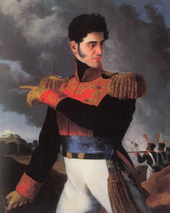
Continuing to anticipate a war, the state legislature on July 11, 1846 by decree enlisted 6,000 men to serve along the border; during that time Ángel Trías quickly rose to power by portraying zealous anti-American rhetoric.
The Treaty of Guadalupe Hidalgo, signed on February 2, 1848, by American diplomat Nicholas Trist and Mexican plenipotentiary representatives Luis G. Cuevas, Bernardo Couto, and Miguel Atristain, ended the war, gave the U.S. undisputed control of Texas, and established the U.S.–Mexican border of the Rio Grande.
Despite the efforts of strong political forces led by Ángel Trías in the state could not stop President Santa Anna from selling La Mesilla as part of the Gadsden Purchase on December 30, 1853 for 15 million USD.
President Juárez, in an effort to organize a strong defense against the French, decreed a list of national guard units that every state had to contribute to the Ministry of War and the Navy; Chihuahua was responsible for inducting 2,000 men.
After the defeat of the army in Puebla, the Juárez administration was forced to abandon Mexico City; the president retreated further north seeking refuge in the state of Chihuahua.
On July 22 Brincourt crossed the banks of Río Florido into Ciudad Jiménez; one day later he arrived at Valle de Allende where he sent Colonel Pyot with a garrison to take control of Hidalgo del Parral.
General François Achille Bazaine ordered the French troops to retreat back to the state of Durango after only reaching a point one days travel north of Chihuahua City.
Maximilian was deeply dissatisfied with General Bazaine's decision to abandon the state capital of Chihuahua and immediately ordered Agustín B. Billaut to recapture the city.
Being completely caught off guard, the French imperial forces sought refuge by bunkering themselves in the Cathedral of the Holy Cross, Our Lady of Regla, and St Francis of Assisi and made it almost impossible to penetrate their defenses.
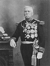
Peace returned to Chihuahua and the new government was led by Governor Antonio Ochoa (formerly a co-owner of the Batopilas silver mines) in 1873 after Luis Terrazas finished his term in 1872.
Later a dispute ensued again among the states of Coahuila, Durango, and Chihuahua over the mountain range area known as Sierra Mojada, when large deposits of gold ore was discovered.
By 1888 the telephone services were extended from the capital to the cities of Julimes, Meoqui, and Hidalgo del Parral; the telecommunication network in the state covered an estimated 3,500 kilometers.
A handful of families owned large estates (known as haciendas) and controlled the greater part of the land across the state while the vast majority of Chihuahuans were landless.
Insisting on a new election, Madero won overwhelmingly in late 1911, and he established a liberal democracy and received support from the United States and popular leaders such as Orozco and Villa.
Villa had the advantage of intimately knowing the inhospitable terrain of the Sonoran Desert and the almost impassable Sierra Madre mountains and always managed to stay one step ahead of his pursuers.
The most common species of flora found in the mountains are: Pinus, Quercus, Abies, Ficus, Vachellia, Ipomoea, Acacia, Lysiloma, Bursera, Vitex, Tabebuia, Sideroxylon, Cordia, Fouquieria, Pithecellobium.
The most common desert flora in the state includes: Agave, Larrea, Prosopis, Fouquieria, Dasylirion, Yucca, Poaceae, Lophophora, Opuntia, Echinocereus, Baileya, Chilopsis, Eucnide, and Hylocereus.
In the mountain zone of the state the most observed mammals are: Mexican fox squirrel (Sciurus nayaritensis), antelope jackrabbit (Lepus alleni), raccoon (Procyon lotor), hooded skunk (Mephitis macroura), collared peccary (Dicotyles tajacu), white-tailed deer (Odocoileus virginianus), mule deer (Odocoileus hemionus), American bison (Bison bison), cougar (Puma concolor), jaguar (Panthera onca), eastern cottontail (Sylvilagus floridanus), North American porcupine (Erethizon dorsatum), bobcat (Lynx rufus), Mexican wolf (Canis lupus baileyi), and coyote (Canis latrans).
The state is also a host to a large population of birds which include endemic species and migratory species: greater roadrunner Geococcyx californianus, cactus wren Campylorhynchus brunneicapillus, Mexican jay Aphelocoma ultramarina, Steller's jay Cyanocitta stelleri, acorn woodpecker Melanerpes formicivorus, canyon towhee Pipilo fuscus, mourning dove Zenaida macroura, broad-billed hummingbird Cynanthus latirostris, Montezuma quail Cyrtonyx montezumae, mountain trogon Trogon mexicanus, turkey vulture Cathartes aura, and golden eagle Aquila chrysaetos.
[citation needed] As of 2007[update], the state's economy employed 786,758 people, which accounted for 3.9% of the country's workforce with annual GDP per capita of 136,417 pesos (12,338 dollars).


|
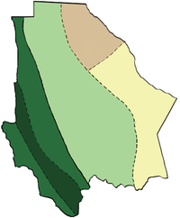
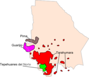
Tarahumara
Tepehuan Del Norte
Guarijío
Pima
|

|
250-1,000 ppl per km
2
25-249 ppl per km
2
5-24 ppl per km
2
1-4 ppl per km
2
|


