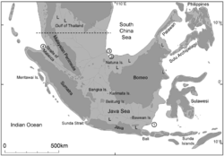
Sunda Shelf
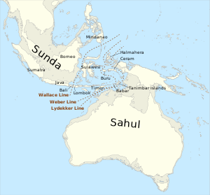
Biogeographically, Sundaland is a term for the region of Southeastern Asia which encompasses these areas of the Asian continental shelf that were exposed during the last ice age.
The shelf has resulted from millennia of volcanic activity and erosion of the Asian continental mass, and the build up and consolidation of debris along the margins as sea levels rose and fell.
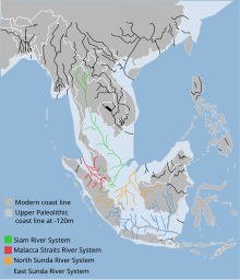
[6] Present sea levels submerge a number of Pleistocene paleo river systems that drained much of Sundaland during the last glacial maximum 18,000 to 20,000 years ago.
Passing between Bali and Lombok, and Borneo and Sulawesi, Wallacea is marked by a transition zone of flora and fauna first described by Alfred Russel Wallace.
During the driest period of the Pleistocene era (about 17,000 years BP) some four distinct catchment areas form the Malacca, Siam and Sunda river systems.
The Malacca Straits river system is formed by a joining of waters from northeastern Sumatra and the western Malay Peninsula, draining into the Andaman Sea.