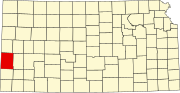
Syracuse, Kansas
Syracuse began its existence as a stop on the Atchison, Topeka and Santa Fe Railway.
[6] Syracuse secured its place in American history on April 5, 1887 by electing an all-woman city council, the first in the nation.
The council consisted of Mrs. N. E. Wheeler (mayor), Caroline Johnson Barber, Mrs. W. A. Swartwood, Mrs. S. P. Nott, Mrs. Charles Coe, and Mrs. G. C.
[7][8] By 1912, Syracuse was home to more than a thousand souls, 2 banks, a hotel belonging to the Fred Harvey Company, a flour mill, several machine shops, 2 weekly newspapers (Syracuse Journal and the Republican-News), 4 churches, a county high school with 10 teachers, a telegraph and express office, and an international money order post office.
[9][10] Syracuse is located along U.S. Route 50 and the Atchison, Topeka and Santa Fe Railway, 16 miles (26 km) from the Colorado border.
Located within these sandhills is the "Syracuse Sand Dunes," a city park covering 1,300 acres (5.3 km2), including a 40-acre (160,000 m2) fishing pond.
According to the United States Census Bureau, the city has a total area of 4.10 square miles (10.62 km2), all of it land.
[12] The 2020 United States census[15] counted 1,826 people, 602 households, and 349 families in Syracuse.
39.0% of households consisted of individuals and 10.8% had someone living alone who was 65 years of age or older.
31.5% of all households were made up of individuals, and 14.3% had someone living alone who was 65 years of age or older.
32.6% of all households were made up of individuals, and 17.7% had someone living alone who was 65 years of age or older.
The community is served by Syracuse USD 494 public school district.